
Existed: 1987 – present Length 26.9 km | Constructed 1987 | |
 | ||
Arizona state route 51 freeway to highland avenue exit 16th street to camelback road phoenix az
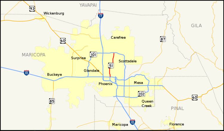
Arizona State Route 51 (SR 51), also known as the Piestewa Freeway, is a numbered state highway in Phoenix, Arizona. It connects Interstate 10 just outside Downtown Phoenix with Loop 101 on the north side of Phoenix, making it one of the area's major freeways. It is a largely north–south route and is known for traversing the Piestewa Peak Recreation Area. The peak was named after Lori Piestewa, the first Native American woman to die in combat in the U.S. Military. Prior to this time, the freeway was known as the Squaw Peak Parkway, a name considered offensive by many Native Americans. Rapid growth and increased traffic demand on the east side of Metro Phoenix made the Piestewa Freeway necessary.
Contents
- Arizona state route 51 freeway to highland avenue exit 16th street to camelback road phoenix az
- Map of AZ 51 Phoenix AZ USA
- Route description
- History
- Exit list
- References
Map of AZ-51, Phoenix, AZ, USA
The freeway was proposed at least as far back as 1955. It was intended to become part of a never-constructed Interstate 510.
Route description
The southern terminus of SR 51 is located at an interchange with I-10 and Loop 202 immediately east of downtown Phoenix. It heads north from the interchange through the northern sections of Phoenix. The freeway travels through some major areas of Phoenix, and past some major services such as the Phoenix Children's Hospital, Arizona Heart Hospital and Heart Institute, and the Camelback Colonnade at 20th Street and Camelback Road. The highway then begins to climb to the top of the Dreamy Draw, a mountain passage between Piestewa Peak and North Mountain, before descending into the Paradise Valley area of North Phoenix. It reaches its northern terminus at an interchange with Loop 101 in northern Phoenix.
History
General Location of National System of Interstate Highways, a 1955 proposal for what would become the Interstate Highway System, included a spur freeway from what would become Interstate 10, proceeding north along a route similar to the modern Piestewa Freeway. The road was later designated I-510. The routing of the freeway later appeared in route logs in 1968 under the designation of State Route 510 and the name Squaw Peak Freeway.
The freeway was originally named the Squaw Peak Parkway. The modern usage of the word squaw, which can be perceived as a derogatory term for Native American women, had led to guidelines from the U.S. Board on Geographic Names that the word should be phased out of the names of natural features. In 2003, Governor Janet Napolitano announced her intent to rename the peak for which the freeway was named. That same year, U.S. Army specialist and Arizona native Lori Piestewa was killed in the 2003 invasion of Iraq. According to U.S. Military records, Piestewa was the first known Native American woman to be killed on foreign soil while serving in combat for the military. As such, Governor Napolitano thought this was an appropriate new name for the peak, which by extension affected the name of the freeway.
The original five miles (8 km) of the freeway between McDowell Road and Glendale Avenue were constructed by the city of Phoenix (as the Squaw Peak Parkway) between 1986 and 1991. The first overpass to be completed was in 1986 at Osborn Road. In 1987, the bridge over the Grand Canal had been completed, as well as the overpass at McDowell Road and the southbound connector to eastbound I-10. Also completed in 1987 were the overpasses at Colter Street and Missouri Avenue that passed over the freeway. Several more overpasses were completed in 1988 including those located at Indian School Road, Highland Avenue, Camelback Road and Bethany Home Road. Also in 1988, the state established a corridor for the freeway from Glendale Avenue north to Loop 101. In 1989, the bridge over the Arizona Canal was complete, as well as the overpass at Thomas Road. The southbound Route 51 connector ramp to eastbound Loop 202 and the 20th Street overpass were completed in 1990. The city of Phoenix had the freeway completed as far north as Glendale Ave. in 1991. During much of the road's early days in the 1990s, several decorative pots were mounted on top of the noise mitigation walls, which were a source of controversy at the time of their installation due to cost and aesthetics. One resident installed a gold toilet in protest. They were all taken down, however, during the ADOT reconstruction project between McDowell Rd. and Shea Boulevard in 2000.
In 1992, the southern portion was handed over to the Arizona Department of Transportation. Since then, it has been extended to Loop 101 and retrofitted with rubberized asphalt, standardized signage, an additional general purpose lane to create three lanes in each direction, and a new high occupancy vehicle lane up to Loop 101.
In 2007, construction began to widen the Piestewa Freeway between Shea Blvd. and the Loop 101 interchange to include a high occupancy vehicle lane in each direction and on ramps to Loop 101 eastbound. Work was completed in the summer of 2008.
In March 2016, a new interchange from the road's existing terminus at Loop 101 to an intersection with Black Mountain Boulevard opened.
Exit list
The entire route is in Phoenix, Maricopa County.