
Area 7.07 km² | Region Normandy Arrondissement Vire Local time Tuesday 9:34 PM | |
 | ||
Weather 7°C, Wind SW at 24 km/h, 88% Humidity | ||
Arganchy is a French commune in the Calvados department in the Normandy region of northwestern France.
Contents
- Map of 14400 Arganchy France
- Geography
- Toponymy
- History
- Administration
- Demography
- Economy
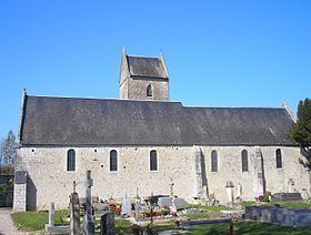
- Sites and Monuments
- References
Map of 14400 Arganchy, France
The inhabitants of the commune are known as Arganchois or Arganchoises
Geography
Arganchy is located in the area of Bessin in the valley of the Gourguichon Stream some 6.5 km south-west of Bayeux and 7 km north-east of Castillon. Access to the commune is by the D192 road from Subles in the west passing through the commune north of the village and continuing east to join National Highway N13 east of Monceaux-en-Bessin. The village is reached by the country road L'Eglise running off the D192. The D572 highway runs through the north-western corner of the commune with an exit onto the D192 at Subles. Apart from the village there are also the hamlets of La Mauvielle, Saint-Amator, La Petite Flague, and Les Feffes in the commune. The commune is entirely farmland.
The Cayennes Stream flows from the south to join the Gourgichon Stream east of the village which flows west to join the Drôme at Aprigny (Agy)agy.
Toponymy
The name Arganchy appears as Archenceium in 1198.
The origin of the name is attributed to the anthroponym Argentius: Latin according to René Lepelley or Gaulish according to Albert Dauzat and Charles Rostaing.
History
In 1829 Arganchy (with 285 inhabitants in 1821) absorbed Saint-Amator (with 52 inhabitants) east of its territory.
Administration
List of Successive Mayors
(Not all data is known)
The council is composed of eleven members including the mayor and two deputy mayors.
Demography
In 2009 the commune had 234 inhabitants. The evolution of the number of inhabitants is known from the population censuses conducted in the commune since 1793. From the 21st century, a census of communes with fewer than 10,000 inhabitants is held every five years, unlike larger towns that have a sample survey every year.
Sources : Ldh/EHESS/Cassini until 1962, INSEE database from 1968 (population without double counting and municipal population from 2006)
Economy
At a place called La Grande Abbaye there is a natural camping ground.