
Country France Canton Quingey Time zone CET (UTC+1) Local time Tuesday 8:37 AM | Area 14.98 km² Population 1,364 (1999) Extension 2009 | |
 | ||
Region Bourgogne-Franche-Comté Weather 7°C, Wind S at 18 km/h, 72% Humidity | ||
Arc-et-Senans is a French commune in the Doubs department in the Bourgogne-Franche-Comté region of eastern France.
Contents
- Map of Arc et Senans France
- Geography
- Toponymy
- History
- Administration
- Demography
- Economy
- Civil heritage
- Religious heritage
- Notable people linked to the commune
- References
Map of Arc-et-Senans, France
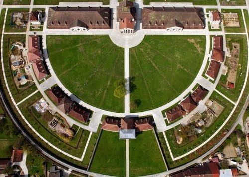
The Royal Saltworks, a UNESCO World Heritage Site since 1982, is located here.
Geography
Arc-et-Senans is a large commune located some 32 km south-west of Besancon and 30 km east by south-east of Dole. It lies between the Loue river in the south and the Chaux forest in the north at 250 metres altitude. The northern western, and southern borders of the commune are the departmental border between Doubs and Jura. Only the short north-eastern border connects the commune to Doubs. Access to the commune is by the D17 from Liesle in the north-east which passes through the town and continues west, changing to the D7 at the border, to Chissey-sur-Loue. The D31 comes from Rans in the north, changing to the D17E at the border, and continues south, changing again to the D32, to Cramans. The commune has several hamlets: Arc to the west of the main town and Senans to the north-east almost link into one town. Then there are also the hamlets of Le Defois and Le Vernois. There is an SNCF railway station at Arc-et-Senans town which is a junction for two lines and is served by the TER Franche-Comté. There are forests to the north but most of the commune is farmland.
The Loue river forms the southern and eastern border of the commune as it continues south to join the Doubs near Molay. The Ruisseau de la Reverotte flows from the north-east of the commune down the western side and forms part of the western border before continuing west to join the Loue east of Belmont.
Toponymy
Arc-et-Senans was known as Petregium (Roche-sur-Loue) cited in the Chronicle by Saint-Benignus. It was Arcum in 1049, Sonans in 1275, Cenans et Arc en Valoye in 1490, and Arc en Vallois in 1681.
History
Traces of occupation dating back to the Roman era have been found, especially at a place called Le Cretot. Bones with broken tiles and bricks were visible in the soil during excavation. Father Letondal in his book Arc-et-Senans through the ages (French) published in 1927 tells a quite complete communal history.
Administration
List of Successive Mayors
(Not all data is known)
Demography
In 2012 the commune had 1,537 inhabitants. The evolution of the number of inhabitants is known from the population censuses conducted in the commune since 1793. From the 21st century, a census of communes with fewer than 10,000 inhabitants is held every five years, unlike larger communes that have a sample survey every year.
Sources : Ldh/EHESS/Cassini until 1962, INSEE database from 1968 (population without double counting and municipal population from 2006)
Economy
The economic life of Arc-et-Senans is largely oriented towards tourism. The Royal Saltworks attracts 150,000 visitors per year (2000). In addition some small industry has developed, mainly in wood and to a lesser extent plastics. Finally there is still about a dozen farms which traditionally are oriented towards dairy cattle and grain farming.
Civil heritage
The commune has a number of buildings and structures that are registered as historical monuments:
Religious heritage
The religious heritage of the town is complemented by several wayside crosses erected in the village and by the presence of two chapels.
The Chapel of Arc was built with donations from parishioners and consecrated in 1913. It is dedicated to the Sacred Heart. The bell tower has been rebuilt over nearly 25 years: farmers funded the work by donating the proceeds of the sale of the dairy factory. A complete renovation of the building was completed in 1997 by a team of volunteers.
The Chapel de la Grotte des Essarts (Chapel of the Essarts Cave) was built after the cholera epidemic of 1854. Father Coutteret vowed to build this monument if the Virgin Mary protected the parish. It is a stone building located on a natural promontory overlooking the village and the Royal Saltworks. A procession is held every 15 August. In 2006 the procession was carried out at night with torches and the chapel was illuminated for the occasion with a generator. The commune has renovated the chapel through a subscription.
The Church of Saint-Bénigne was built in the 19th century in the classical style. The bell tower was rebuilt exactly in 1921 following a fire caused by a storm. The church has two organs. It also has many items that are registered as historical objects: