
Intercommunality Vallée de Barétous Area 29.55 km² | Canton Aramits Time zone CET (UTC+1) Population 666 (2006) | |
 | ||
Aramits is a French commune in the Pyrénées-Atlantiques department in the Nouvelle-Aquitaine region of south-western France.
Contents
- Map of 64570 Aramits France
- Location
- Access
- Hydrography
- Toponymy
- History
- Administration
- Inter communality
- Demography
- Economy
- Religious heritage
- Environmental heritage
- Education
- Sports and sports facilities
- Notable people linked to the commune
- References
Map of 64570 Aramits, France
The inhabitants of the commune are known as Aramitsiens or Aramitsiennes.
Location
Aramits is located in part of the Barétous valley, the westernmost of the three main valleys of Béarn crossing the Pyrenees. It is located some 15 km south-west of Oloron-Sainte-Marie and 3 km north of Arette.
Access
Access is by the D919 road from Ance in the north-east to the village then continuing to Lanne-en-Baretous in the south-west. There are also the minor roads D659 from the village north to join the D159 on the northern border and the D133 which goes south from the village to Arette.
Bus route 848 of the Inter-urban network of Pyrénées-Atlantiques, which connects La Pierre Saint-Martin (a ski resort in Arette) to Oloron-Sainte-Marie, has a stop in Aramits.
Hydrography
Located in the drainage basin of the Adour, the commune is bisected from south-west to north-east by : Le Vert a tributary of the Gave d'Oloron which gathers many tributaries of its own in the commune including the Aurone, the Lancy, the Littos, the Talou Gros, and also by the arrècs of Bugalaran, Bitole (as well its tributary the Rachet), Ibarcis, and Labaigt (and by its tributary the Audore).
The tributaries of the Joos: the Arriou de Sulu and the Bouhatéko erreka (with the Dragon) also flow through the commune.
Toponymy
The commune name in béarnais is Aràmits (according to classical norm of Occitan). For Brigitte Jobbé-Duval, the origin of the name is from the Basque aran ("valley") and -itz (a locative and collective suffix) giving "place of valleys" or "confluence". It would also indicate that the inhabitants were once nicknamed grenouilles (frogs) - a name for the inhabitants of wetlands).
The following table details the origins of the commune name and other names in the commune.
Sources:
Origins:
History
Paul Raymond on page 7 of his 1863 dictionary that Aramits is the former capital of the Barétous valley and that there were two Lay Abbeys, vassals of the Viscounts of Béarn: The Abadie-Susan and Abadie-Jusan.
He further noted that in 1385 there were 52 fires at Aramits and it depended on the bailiwick of Oloron.
Shortly before (in 1375), the priest of Aramits played the role of mediator in conflicts between the Spaniards and the French which gave birth to the treaty called the Junta de Roncal.
In 1790, the Canton of Aramits also included Esquiule.
On 13 March 2000 Aramits was hit by an earthquake of magnitude 4.2.
Administration
List of Successive Mayors
(Not all data is known)
Inter-communality
Aramits is part of five inter-communal structures:
Demography
In 2009 the commune had 677 inhabitants. The evolution of the number of inhabitants is known from the population censuses conducted in the commune since 1793. From the 21st century, a census of communes with fewer than 10,000 inhabitants is held every five years, unlike larger towns that have a sample survey every year.
Sources : Ldh/EHESS/Cassini until 1962, INSEE database from 1968 (population without double counting and municipal population from 2006)
Economy
The economy of the town is primarily oriented toward agriculture and livestock (cattle and sheep). It is part of the Appellation d'origine contrôlée (AOC) zone designation of Ossau-iraty.
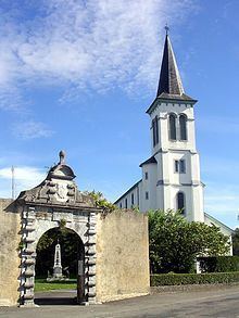
Religious heritage
The Parish church of Saint-Vincent (17th century) is registered as an historical monument. It was a former Lay Abbey with the remains of a portal from the 17th century but the old church was demolished in 1880. The new Romanesque-Byzantine style church was built from 1884 to 1886.
Environmental heritage
Education
The commune has a primary school.
Sports and sports facilities
Rugby Union: the Entente Aramits plays in Fédérale 2. Pierre Capdevielle played there from 1985 to 1994.