
1910 6,048 km (2,335 sq mi) Area 6,048 km² | Established 11th century 1910 414,388 | |
 | ||
Arad County was an administrative unit in the Kingdom of Hungary, the Eastern Hungarian Kingdom and the Principality of Transylvania. The county was established along the Maros river in the 11th or the 12th century, but its first head, or ispán, was only mentioned in 1214. Its territory is now in western Romania and south-eastern Hungary. The capital of the county was Arad.
Contents
Geography
The medieval Arad County was situated in the lands along both banks of the Maros River. The existence of arable lands, pastures, vineyards and orchards in the western lowlands in the Middle Ages is well-documented. The hilly eastern regions were sparsely populated. The total territory of the medieval county was around 3,800 km2 (1,500 sq mi).
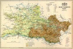
Arad county shared borders with the Hungarian counties Csanád, Békés, Bihar, Torda-Aranyos, Hunyad, Krassó-Szörény, Temes and Torontál. The river Maros formed its southern border. The Fehér-Körös river flowed through the county. Its area was 6,078 km2 (2,347 sq mi) around 1910.
Origins
The Hungarians dominated the region of the Maros in the middle of the 10th century, according to the Byzantine Emperor Constantine Porphyrogenitus. Archaeological finds also shows that Hungarians settled in the plains along the river after their arrival in the Carpathian Basin at the end of the 9th century. Place names of Slavic origin (including Lipova (Lippa) and Zăbrani (Temeshidegkút)) evidence the presence of Slavic speaking communities, especially in the region where the river, coming from the mountains, reached the lowlands.
A powerful chieftain, Ajtony, ruled the territory along the rivers Danube, Maros, and Tisza in the early 11th century. The Maros formed the northern border of Ajtony's realm, according to the Gesta Hungarorum, but the longer version of the Legend of Saint Gerard wrote that he controlled the lands as far as the Körös River. Ajtony was killed in a battle against the army of Stephen I of Hungary, which was under the command of one Csanád. According to a scholarly theory, first proposed by historian György Györffy, Stephen I established Arad County after Ajtony's fall. On the other hand, historian Gyula Kristó writes that Ajtony's whole realm was transformed into the large Csanád County during Stephen I's reign; Arad County only developed into a separate administrative unit in the second half of the 11th century or in the 12th century.
Middle Ages
The remains of an 11th-century stronghold, made of earth and timber, were found at Arad. At an assembly held in Arad in 1131, the wife of King Béla the Blind, Helena of Rascia, ordered the massacre of 68 Hungarian lords. Arad Castle and the estates attached to it were first documented in a royal charter, issued in 1177. The first known ispán, or head, of Arad County, Paul Csanád, was mentioned in a royal diploma, dated to 1214, but its authenticity is suspect. The earliest authentic document that referred to an ispán of Arad was issued in 1240. The western regions of the county were included in the Deanery of Arad of the Roman Catholic Diocese of Csanád; the Archdean of Arad was first mentioned in 1288.
The earliest documents suggest that the kings owned most lands in the plains along the Maros. However, the distribution of royal domains started at the end of the 11th century. For instance, Ladislaus I of Hungary and his brother, Lampert, granted five villages to the Titel Chapter before 1095 and Béla the Blind established the Arad Chapter in the 1130s. The Hodos clan was the only local noble kindred in the county; they were the patrons of the Hodos Monastery. Members of the Csanád, Csák and Dorozsma clans received estates in Arad County in the early 13th century.
The effects of the Mongol invasion cannot exactly be determined, but at least four monasteries disappeared. Solymos Castle (in present-day Șoimoș in Lipova), the first fortress built by a nobleman in the county, was erected after the withdrawal of the Mongols. Ecclesiastic institutions, prelates and lay lords – including the bishop of Csanád, the Arad Chapter and the Garais, Lackfis and Telegdis – held most former royal estates in the first half of the 14th century. The existence of four elected "judges of the nobles" was first documented in 1311, proving that Arad County had transformed into a "noble county", an institution of the local noblemen's self-government.
Lippa (present-day Lipova, Arad) became the most prosperous settlement in the early 14th century: the tax payable by the local priest to the Holy See between 1333 and 1335 (266 dinars) was almost ten times higher than the average tax collected in other parishes. The Slavs of the district of Lipova were converted into Catholicism in the middle of the century, according to John of Küküllő's contemporaneous chronicle. The earliest Romanian place name in the county – Caprewar (now Căprioara) – was recorded in a list of the estates of the Telegdis which was completed in 1337.
Modern Times
In 1920 the Treaty of Trianon assigned most of the territory of Arad county to Romania, except a small area south of Békéscsaba, which became part of the new Hungarian county Csanád-Arad-Torontál. Since World War II the Hungarian part of Arad county is part of the Hungarian county Békés.
The rest of the county is now part of the Arad County in Romania. This county also contains parts of the former counties Temes and Krassó-Szörény.
1900
In 1900, the county had a population of 386,100 people and was composed of the following linguistic communities:
Total:
According to the census of 1900, the county was composed of the following religious communities:
Total:
1910
In 1910, the county had a population of 414,388 people and was composed of the following linguistic communities:
Total:
According to the census of 1910, the county was composed of the following religious communities:
Total:
Subdivisions
In the early 20th century, the subdivisions of Arad county were:
Elek is now in Hungary; the other towns mentioned are in Romania.