
Country Philippines Capital Kabugao* Time zone PHT (UTC+8) University Apayao State College | Founded February 14, 1995 Area rank 27th out of 81 Municipalities 7 | |
 | ||
Region Cordillera Administrative Region (CAR) | ||
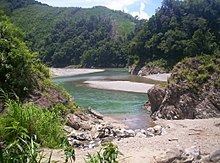
Apayao tourist spot must watch thankyou
Apayao (Ilocano: Probinsya ti Apayao, Filipino: Lalawigan ng Apayao) is a landlocked province in the Philippines in the Cordillera Administrative Region in Luzon. Its capital town is Kabugao.
Contents
- Apayao tourist spot must watch thankyou
- Map of Apayao Philippines
- Spanish period
- American period
- World War II
- Kalinga Apayao creation and splitting
- Geography
- Climate
- Administrative divisions
- Barangays
- Demographics
- Economy
- References
Map of Apayao, Philippines
The province borders Cagayan to the north and east, Abra and Ilocos Norte to the west, and Kalinga to the south. Prior to 1995, Kalinga and Apayao comprised a single province named Kalinga-Apayao, which was partitioned to better service the needs of individual ethnic groups.
With a population of 119,184 (as of the 2015 census) covering an area of 4,413.35 square kilometres (1,704.00 sq mi), Apayao is the least densely-populated province in the Philippines.
Spanish period
Although Apayao, which was then part of Cagayan, was among the earliest areas penetrated by the Spaniards in the Cordilleras, the region, inhabited by the Isneg tribe, remained largely outside Spanish control until late in the 19th century. As early as 1610, the Dominican friars established a mission in what is now the town of Pudtol. In 1684, the friars again made attempts to convert the people and established a church in what is now Kabugao.
The Spanish authorities were then able to establish in Cagayan the comandancias of Apayao and Cabugaoan in 1891, which covered the western and eastern portions of what is now Apayao. The comandancias, however, failed to bring total control and the Spanish government only maintained a loose hold over the area.
American period
The Americans established the Mountain Province on August 13, 1908, with the enactment of Act No. 1876. Apayao, along with Amburayan, Benguet, Bontoc, Ifugao, Kalinga, and Lepanto, became sub-provinces of this new province.
World War II
In 1942, Japanese Imperial forces entered Apayao, starting a three-year occupation of the province during the Second World War. Local Filipino troops of the 1st, 2nd, 12th, 15th and 16th Infantry Division of the Philippine Commonwealth Army and the military forces of the USAFIP-NL 11th and 66th Infantry Regiment, supported by the Cordilleran guerrillas, drove out the Japanese in 1945.
Kalinga-Apayao creation and splitting
On June 18, 1966, the huge Mountain Province was split into four provinces with the enactment of Republic Act No. 4695. The four provinces were Benguet, Bontoc (renamed "Mountain Province"), Kalinga-Apayao and Ifugao. Kalinga-Apayao, along with Ifugao, became one of the provinces of the Cagayan Valley region in 1972.
On July 15, 1987, the Cordillera Administrative Region was established and Kalinga-Apayao was made one of its provinces.
Finally, on February 14, 1995, Kalinga-Apayao was split into two independent provinces with the passage of Republic Act No. 7878.
Geography
Apayao is basically situated within the Cordillera Central mountains, traversed by many rivers. The province covers an area of 4,413.35 square kilometres (1,704.00 sq mi) forming the northern tip of the Cordillera Administrative Region, and is bounded on the north and east by Cagayan, west by Ilocos Norte, southwest by Abra and south by Kalinga.
Plains and valleys are used for farming. Apayao is basically composed of farmlands.
Climate
The prevailing climate in the province falls under Corona's Type III Classification. It is characterized by relatively dry and wet seasons, from November to April, and wet during the rest of the year. Heaviest rain occurs during December to February while the month of May is the warmest.
Administrative divisions
Apayao comprises 7 municipalities, all encompassed by a lone legislative district.
Barangays
The 7 municipalities of the province comprise a total of 133 barangays, with Barangay Malama in Conner as the most populous in 2015, and Eleazar in Calanasan as the least.
Demographics
The population of Apayao in the 2015 census was 119,184 people, with a density of 27 inhabitants per square kilometre or 70 inhabitants per square mile.
Based on the 2000 census survey, Ilocanos comprised 49,328 (7001508200000000000♠50.82%) of the total provincial population of 97,058, while almost 1/3 of the population were Isnag at 29,071 (7001299500000000000♠29.95%). Other ethnic groups in the province were the Malaueg at 3,580 (7000369000000000000♠3.69%), Isneg at 3,380 (7000348000000000000♠3.48%), Kalinga at 2,992 (7000308000000000000♠3.08%), Kankanaey at 1,208 (7000124000000000000♠1.24%), Bontoc at 1,014 (7000104000000000000♠1.04%), and Ibaloi at 979 (7000101000000000000♠1.01%).
Economy
Apayao is devoted to agricultural production, particularly food and industrial crops such as palay, corn, coffee, root crops and vegetables. Fruits produced include lanzones, citrus, bananas and pineapples, durian, santol, rambutan, coconut and mangosteen. Rice production totaled 98,489 metric tons in 2011.
Economic activity is also based on livestock and poultry breeding such as swine, carabao, cattle, goat and sheep. Other additional investment includes manufacturing, food processing, furniture, crafts and house wares making.
Updated records of the Department of Trade and Industry Provincial Office reveal that existing industries in the province are furniture, garment craft, food processing, gifts and house wares, and agricultural support.