
Founded October 16, 1870 Website www.apaxco.gob.mx Population 27,521 (2010) | State Mexico (state) Elevation 2,213 m (7,260 ft) Area 80.34 km² Local time Monday 4:23 AM | |
 | ||
Time zone Central Standard Time (UTC-6) Weather 9°C, Wind E at 8 km/h, 46% Humidity | ||
Califican de d spota a alcalde de apaxco jes s cruz parra
Apaxco is a municipality located in the Zumpango Region, in the northeastern part of the State of Mexico in Mexico. The municipal territory is located at a southern pass leading out of the Mezquital Valley about 288 km (179 mi) northeast of the state capital of Toluca. The name Apaxco comes from Nahuatl, and means "place of the water fall".
Contents
- Califican de d spota a alcalde de apaxco jes s cruz parra
- Map of Apaxco State of Mexico Mexico
- Geography
- Flora and fauna
- History
- Communication and transport
- Demography
- Religion
- Health
- Culture
- Monuments
- Sports and Entertainment
- References
Map of Apaxco, State of Mexico, Mexico
The municipality, founded on October 16, 1870, It covers an area of 80.34 square kilometres (31.02 sq mi). Apaxco de Ocampo is a municipal seat, and is a border city with Vito and El Refugio (between the State of Mexico and the State of Hidalgo; inside of Cuenca cementera). It is an important area for the building industry, although it has ecological problems.
Geography
The town of Apaxco de Ocampo is a municipal seat, with jurisdiction over the following communities: Coyotillos, Santa María, Loma Bonita, Pérez de Galeana and Colonia Juárez. The total municipality extends 84.37 km2 and borders with the municipalities of Tequixquiac, Hueypoxtla and the state of Hidalgo (with Atotonilco de Tula and Ajacuba).
The Gran Canal de Desagüe is an artificial channel that crosses Apaxco, and was named Xothé river in the Otomi language. This channel connects with the Tula River and the Endhó dam. Other small rivers are Treviño, Zarco, El Codo and Teña, which connect with the Gran Canal. Apaxco has thermal waters, and subterranean rivers with hot springs, called Los Bañitos.
The municipal seat is in a small, elongated valley, but most of the municipality is on a high mesa which transitions from the Valley of Mexico to the Mezquital Valley. The highest mountains in Apaxco are the Cerro El Estudiante, Cerro Teña, Cerro Coyotillos, Cerro Blanco and Cerro Pelón in Tezontlalpan Sierra. Other mountains are Mesa Ahumada or Cerro Colorado in the border between the municipalities of Huehuetoca and Tequixquiac. Apaxco de Ocampo has a big crater named El Hoyo, which the Aztec people named apatztli in the Nahuatl language.
Apaxco municipality is a rural territory of the Central Mexican Plateau: and has a semi-desert climate, in the south of Mezquital Valley.
Flora and fauna
The flora are different since it is mainly semi-desert land with calcium stones, and the plants consist of cacti and trees with low water needs. Apaxco has chollas, prickly pears, mesquites, huizaches, golden barrels, creosote bush, century plants, and others. In high Sierra de Tetzontlalpan there are oaks, piñon pines and cedars. In Cerro Mesa Ahumada there are other species such as ferns, tejocote trees, white zapote trees, kidneywood trees, tepozans and visnagas.
Apaxco has many native animals. Birds include the owl, eagle, falcon, turkey, colibri, turkey vulture, northern mockingbird, rufous-crowned sparrow, lesser roadrunner, and roadrunner.The reptiles and amphibians include rattlesnakes, pine snakes, xincoyotes, axolotls, frogs, and toads. The insects are red ants, bees, and others. Apaxco has two mountain ranges, where there is primarily a diversity in mammals.The south is Cerro Mesa Ahumada with cacomistle, skunk, gopher, Virginia opossum, rabbit, Mexican gray squirrel and to north with the Sierra de Tetzontlalpan, where there are bobcat, coyote and hare.
History
The first settlers in the region date back to 5000 BC, evidence of which is the expression carved on the stones around of the mountains. This region was inhabited by megafauna such as cuvieronius, two valleys divided but a mountain range (Sierra de Tetzontlalpan), was a habitat for many big animals such as mammoth, glyptodonts and others.
The first inhabitants were Otomian group ancestors. The civilizations that inhabited what is now Apaxco had a direct relationship with the Teotihuacan civilization, until they declined to between 650 and 900, after that were dominated by the Toltecs.
The most important source about Apaxco in pre-Columbian history, was in 1215, during the pilgrimage to the mythical promised city of the Aztecs, was the site Apaxco, In page XI of Boturini Codex is registered places of Atotonilco and Apaxco during the pilgrimage.
With the rise of the Aztec Empire, Apaxco region and all the neighbors were under the government of Tlacopan, one of the members of the Triple Alliance. Tenochcas subjugated the Otomi people and founded the Teotlalpan, a desert region with abundant mountains. Apaxco, Tula and Ajoloapan were places rich in lime which was a very coveted mineral for building, so the lime was a tax payment for the Aztec empire.
Apaxco remained in this position until the fall of Tenochtitlan before the army of Hernán Cortés. In colonial times Apaxco Commit entered the system imposed by the Spanish conquerors, and came under the command of Cristóbal Hernandez Mosquera in 1530.
Apaxco was erected as a township in 1870 after the end of the French intervention, the first school was founded in 1880. But during the Porfirio Díaz government, the municipality entered into a phase of strong economic recession and the town disappeared in 1899 for failing to keep administrative or economically, from that date until 1923 Apaxco was a part from Texquiquiac municipality.
In 1900 the engineer Luis Espinosa built a first calcium oxide factory in Apaxco, was inaugurated by president Porfirio Díaz. This factory was named in 1911 as Calera de Apasco Company. After in 1934 was built Cementos Apasco by shares of engineer Federico Garcia Cuéllar, was bad production and labor exploitation with the workers, in 1964 this cement factory was sold to Swiss company named Holderbank (now Holcim).
Communication and transport
The Arco Norte is a principal highway that crosses by Apaxco. This municipality has three state roads: Zumpango-Apaxco number 9 which connects Mexico City to Atitalaquia, State of Hidalgo. The west road, Huehuetoca-Apaxco number 6 cross Santa María, junctions to Conejos in Atotonilco de Tula, with connection to the Tula-Jorobas highway. The other municipal road connects with Pérez de Galeana and Coyotillos.
Demography
At the census of 2010, there were 27,521 people, The population density was 343/km2 (890/sq mi). The median age was twenty-four years.
Religion
Catholic Christianity represents 98% of the total population of the municipality, 15,796 in 1990. The parish belongs to the Diocese of Cuautitlán.
Health
There is a regional IMSS hospital. This municipality has three public health clinics: ISEM in Apaxco de Ocampo, Santa María Apaxco, and Coyotillos town. The principal causes of death are respiratory problems caused by cancer and pneumonia.
Culture
The Archeological Museum of Apaxco is an important site at main plaza where there is interesting archeological pieces from Toltec, Aztec and Teotihuacan cultures.
Monuments
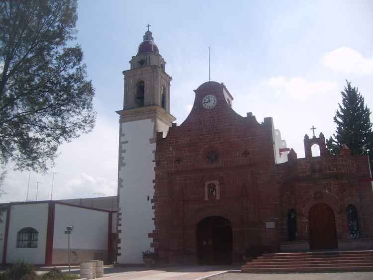
Saint Francis parish is a monument within Apaxco de Ocampo. This temple was constructed in various phases, and was started by Franciscan priests. The atrium was a large space encased in stone with a cross on top of it, but with Christian and indigenous symbols, inside is boveda (arched ceiling) with a chorus to the baroque altar. The facade contains two doorways that are elaborately decorated in stonework which contain indigenous symbolism as well. The temple and the town are dedicated to the Saint Francis of Assisi.
La Misión chapel is a monument in Apaxco de Ocampo town. This chapel, constructed in the Spanish period, is a small Christian Catholic church occupied by monastery priests for the purpose of evangelizing the indigenous people.
Railroad station Apaxco is a building that was constructed in the 19th century to connect a Tula railway to Querétaro City.
Sports and Entertainment
The first sport practiced in Apaxco has been the football soccer. When arrived the factory workers for the Cementos Apaxco, racquetball is a sport practised in this township. Today is played racquetball at Deportivo Apaxco in Loma Bonita, site at south of town (Santa María road cross) and other sports as soon as baseball and basketball.
The hills of Apaxco had used by cows and sheep; the Spanish had very large haciendas and found it necessary to employ indigenous people as vaqueros or herdsman, who soon became excellent horsemen. This situation, is practiced the charrería here.