
Intercommunality Les Vallons du Guiers Area 9.82 km² | Canton Chartreuse-Guiers Population (2014) 2,797 Local time Monday 9:27 AM | |
 | ||
Weather 7°C, Wind S at 5 km/h, 79% Humidity | ||
Aoste is a French commune in the Isère department in the Auvergne-Rhône-Alpes region of southeastern France.
Contents
- Map of Aoste France
- Geography
- History
- Administration
- Demography
- Jambon Aoste
- Sites and Monuments
- Protected Natural Areas
- References
Map of Aoste, France
The inhabitants of the commune are known as Aostiens or Aostiennes, alternatively Dutards or Dutardes
Geography
Aoste is located some 15 km east of La Tour-du-Pin and 8 km north-east of Les Abrets. Access is by the D1516 road from La Batie-Montgascon in the west passing through the village and continuing north-east to Champagneux. The D82F also runs off this road just west of the village and goes north-west to Corbelin. The D40 road from Les Avenieres in the north passes down the eastern side of the commune and continues to Romagnieu. The D592 branches off the D40 on the northern border and goes south to the village continuing to Chimilin in the south. Apart from the village there are also the hamlets of Saint-Didier in the north at the intersection of the D592 and the D40, and Les Champagnes in the east which is really an extension of the urban area of Saint-Genix-sur-Guiers across the border. The rest of the commune is entirely farmland except for the large industrial complex of Jambon d'Aoste north of the village.
The eastern border of the commune is formed by the Guiers river which flows north to join the Rhône which forms the north-eastern border of the commune. The Rhône is the border between Isère and Ain departments while the Guiers is the border between Isère and Savoie departments. The Bièvre river also flows through the west of the commune from the south forming the northern border before joining the Rhone. Numerous other small waterways join the Bièvre.
History
In 2006 archaeological excavations unearthed a pottery workshop dating from the late Middle Ages.
Administration
List of Successive Mayors
(Not all data is known)
Demography
In 2009 the commune had 2,463 inhabitants. The evolution of the number of inhabitants is known from the population censuses conducted in the commune since 1793. From the 21st century, a census of communes with fewer than 10,000 inhabitants is held every five years, unlike larger towns that have a sample survey every year.
Sources : Ldh/EHESS/Cassini until 1962, INSEE database from 1968 (population without double counting and municipal population from 2006)
Jambon Aoste
The pork products produced in Isère department and especially the Jambon Aoste (Aoste Ham) are manufactured exclusively in this Groupe Aoste factory which was owned by the industrial group Sara Lee Corporation who ceased their activities in deli products and resold the operation to the American buyer Smithfield Foods through which it passed to the Chinese group Shuanghui in September 2013.
These industrial products with the "Jambon Aoste" label should not be confused with the official name "Vallée d’Aoste Jambon de Bosses" which is a ham produced in the Aosta Valley (An Italian/French Valley) and which has a protected designation of origin. The Ham products produced in Isère have a simple trademark and no Label Rouge, AOC or PDO regulates its production of cooked or raw ham, unlike the Italian Aosta ham which is a vintage handmade product made in very small quantities.
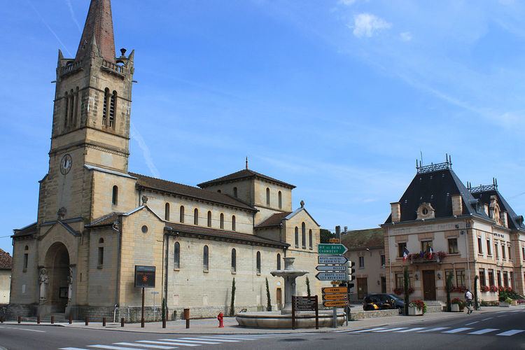
Sites and Monuments
Protected Natural Areas
The commune has two natural zones of ecological interest, fauna and flora of type I: