
Coat of arms Flag Rural localities 29 Area 3,885 km² | Founded 23 March 1935 | |
 | ||
Municipally incorporated as | ||
Anuchinsky District (Russian: Ану́чинский райо́н) is an administrative and municipal district (raion), one of the twenty-two in Primorsky Krai, Russia. It is located in the south of the krai and borders with Spassky District in the north, Yakovlevsky District and the territory of Arsenyev Town Under Krai Jurisdiction in the northeast, Chuguyevsky District in the east, Partizansky District in the southeast, the territory of Partizansk Town Under Krai Jurisdiction in the south and southeast, Shkotovsky District in the south and southwest, and with Mikhaylovsky and Chernigovsky Districts in the west. The area of the district is 3,769.4 square kilometers (1,455.4 sq mi). Its administrative center is the rural locality (a selo) of Anuchino. Population: 14,613 (2010 Census); 16,010 (2002 Census); 18,187 (1989 Census). The population of Anuchino accounts for 30.5% of the district's total population.
Contents
Map of Anuchinsky District, Primorskiy Kray, Russia
Geography
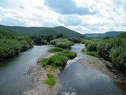
The district is located in humid continental climate zone where the Sikhote-Alin mountains and plains of Khanka lowlands come together. As a result, the area has rich flora and fauna.
Economy
Agriculture is characterized by potato, vegetables, rice, cereals, and panax growth. Milk and meat cattle breeding is very developed in district.