
Population 461 (2011) Civil parish Antony Local time Sunday 8:41 PM | OS grid reference SX 399 547 Dialling code 01752 | |
 | ||
Weather 9°C, Wind SW at 19 km/h, 91% Humidity Points of interest Antony House, Tregantle Fort, Wacker Quay | ||
Antony (Cornish: Trevanta) is a coastal civil parish and a village in Cornwall, England, United Kingdom.
Contents
Map of Antony, UK
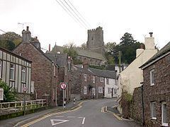
The village is situated on the Rame Peninsula about three miles west of Torpoint and has a shop, a pub and a garage.
Antony parish is bounded to the north by the tidal River Lynher (also known as the St Germans River) and to the south by the English Channel coast. To the east, the parish is bordered by Torpoint and St John parishes and to the west by Sheviock parish.
The parish is in the St Germans Registration District and had a population of 436 at the 2001 census, increasing to 461 at the 2011 census. Apart from the church town, Antony, the only settlement of any size is Wilcove. Scraesdon Fort and Antony House are also in the parish.
At the time of Domesday Book (1086) the manor of Antony was held by Ermenhald from Tavistock Abbey.
Parish church
The medieval parish church is located in Antony at grid reference SX 399 547. Dedicated to St James, the church includes structural elements from the 13th, 14th and 15th centuries. The church houses memorials to members of the Carew family of Antony (18th century) and a large monumental brass to Margery Arundell, 1420.
Notable residents
Twinning
Antony is twinned with Benodet (Benoded) in Brittany, France.