
Airport type Public 16/34 5,498 | Elevation AMSL 300 ft / 91 m 5,498 1,676 Elevation 91 m | |
 | ||
Owner Anson County, North Carolina | ||
Anson county airport
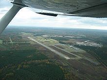
Anson County Airport (ICAO: KAFP, FAA LID: AFP) is a public airport located three miles (5 km) north of the central business district of Wadesboro, a town in Anson County, North Carolina, United States. It is owned by Anson County.
Contents
Although most U.S. airports use the same three-letter location identifier for the FAA and IATA, Anson County Airport is assigned AFP by the FAA but has no designation from the IATA.
Anson county airport after 1989 tornado
Facilities and aircraft
Anson County Airport covers an area of 286 acres (116 ha) which contains one asphalt paved runway (16/34) measuring 5,498 x 100 ft (1,676 x 30 m). For the 12-month period ending August 3, 2005, the airport had 7,200 aircraft operations, an average of 19 per day: 90% general aviation, 7% air taxi and 3% military. There are 32 aircraft based at this airport: 66% single engine, 25% ultralight, 6% multi-engine and 3% gliders.
History
The Anson County Airport was originally equipped with a runway only 3,464 ft (1,056 m). long. In 2006, a new 5,500 ft (1,700 m). runway was completed, in addition to a new 2,400 sq ft (220 m2). terminal building and several new hangars. Future plans for the airport include the addition of a new Instrument Landing System.