
Country Philippines Barangays ZIP code 5717 Local time Sunday 1:12 AM | District Lone district Time zone PST (UTC+8) Area 66.17 km² Province Antique | |
 | ||
Region Western Visayas (Region VI) Weather 26°C, Wind NE at 18 km/h, 78% Humidity Neighborhoods Nato, Salvacion, Poblacion, Butuan Points of interest Nogas Island, Nogas Island Lighthouse, NOGAS ISLAND ANINI-Y, Nogas Island White Sand Beach | ||
Nogas island anini y antique
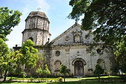
Anini-y, officially the Municipality of Anini-y (Karay-a: Banwa kang Anini-y; Hiligaynon: Banwa sang Anini-y; Filipino: Bayan ng Anini-y), is a municipality in the province of Antique in the Western Visayas (Region VI) of the Philippines. The population was 21,201 at the 2015 census. In the 2016 electoral roll, it had 11,642 registered voters.
Contents
- Nogas island anini y antique
- Map of Anini y Antique Philippines
- Geography
- Barangays
- Demographics
- Attractions
- References
Map of Anini-y, Antique, Philippines
Formerly, Anini-y was not considered as a separate town but rather a sitio of Dao, which was recently renamed to Tobias Fornier after the congressman of Antique. The current mayor of the town is Reynaldo Belleza Pollicar, who was a former vice-mayor.
Geography
Anini-y is located at 10°26′N 121°56′E.
According to the Philippine Statistics Authority, the municipality has a land area of 66.17 square kilometres (25.55 sq mi) constituting 7000242000000000000♠2.42% of the 2,729.17-square-kilometre- (1,053.74 sq mi) total area of Antique.
Barangays
Anini-y is politically subdivided into 23 barangays.
The barrio of San Ramón was formerly the sitio of Igdacoton in the barrio of Magdalena.
Demographics
In the 2015 census, Anini-y had a population of 21,201. The population density was 320 inhabitants per square kilometre (830/sq mi).
In the 2016 electoral roll, it had 11,642 registered voters.