
Postcode(s) 5117 State electorate(s) Light (2011) Postal code 5117 | Local time Saturday 9:41 PM | |
 | ||
Population 2,363 (2011 census)1,359 (2006 census) Location 31 km (19 mi) North of Adelaide12 km (7 mi) West of Gawler Weather 17°C, Wind SE at 14 km/h, 62% Humidity Federal division Division of Wakefield (2011) | ||
Angle vale vs oisc
Angle Vale is a semi-rural town on the Adelaide Plains between Gawler and Virginia. It is steadily being surrounded by Adelaide's suburban sprawl. It is in close proximity to many vinyards and farms. The town includes Trinity College's Gawler River campus, and Angle Vale Primary School, but no secondary school. Many students travel to nearby towns or to Gawler
Contents
- Angle vale vs oisc
- Map of Angle Vale SA 5117 Australia
- Angle vale primary school peoples choice sa region wakakirri 2016
- References
Map of Angle Vale SA 5117, Australia
Angle Vale Post Office opened on 1 October 1866. A Foodland supermarket opened in 2007, along with an assortment of other new stores, replacing an older shopping area. Part of this shopping area remains as a fruits & vegetables store.
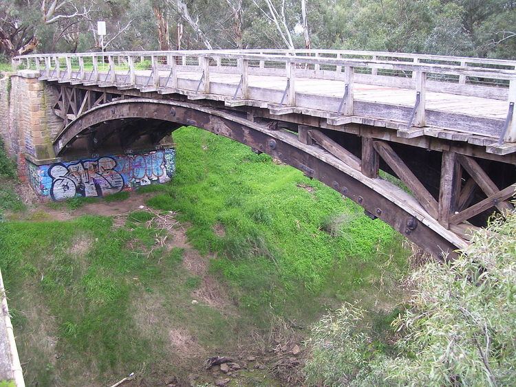
The laminated timber arch Angle Vale Bridge was constructed over the Gawler River in 1876, and is one of the oldest surviving bridges of its type. It is located just north of the center of town.