Postal codes 16278 Population 14,598 (31 Dec 2008) | Time zone CET/CEST (UTC+1/+2) Dialling codes 03331 Local time Saturday 11:37 AM | |
 | ||
Weather 5°C, Wind SW at 16 km/h, 69% Humidity Points of interest Tierpark Angermünde, Naturschutzgebiet Grumsiner Forst/Redernswalde, Ehm‑Welk‑Literaturmuseum, Erlebniszentrum Blumberger Mühle, Blumberger Mühle NABU‑Be | ||
Angermünde ( [aŋɐˈmʏndə]) is a town in the district of Uckermark in the state of Brandenburg, Germany. It is about 43 miles (69 km) northeast of Berlin, the capital of Germany.
Contents
Map of Angerm%C3%BCnde, Germany
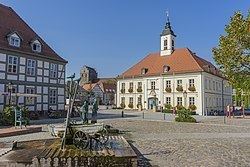
The population is about 10,000, but the population has been rapidly falling as its traditional industrial base (enamel-working) has declined. An administrative sub-centre of its district, it has several Protestant churches, a former Franciscan church, a number of schools of higher learning and a recently refurbished historic marketplace with an old town hall. Located in the game-filled forests of the Uckermark, with its many lakes, it now relies heavily on tourism and the sources of revenue linked to it.
Name
The town is named for its position on the Mündesee.
History
The town was the site of a 1420 victory of Frederick I of Brandenburg over the Pomeranians.
In the 19th century, the town was the seat of a Prussian circle in the province of Brandenburg and linked to Berlin by the Berlin–Stettin (now Szczecin, Poland) railway. Angermünde station then served as the junction for sidelines servicing Prenzlau, Bad Freienwalde, and Schwedt.
In the 20th century, it formed part of East Germany.
Mayors
Frederik Bewer was elected in May 2016 with 95,3 % of the votes for a term of eight years.
