
Country Ukraine Time zone EET (UTC+2) Area code +380 562 | Established 1918 Postal code 70403 Area 71.63 km² | |
 | ||
Municipality Dnipropetrovsk Municipality | ||
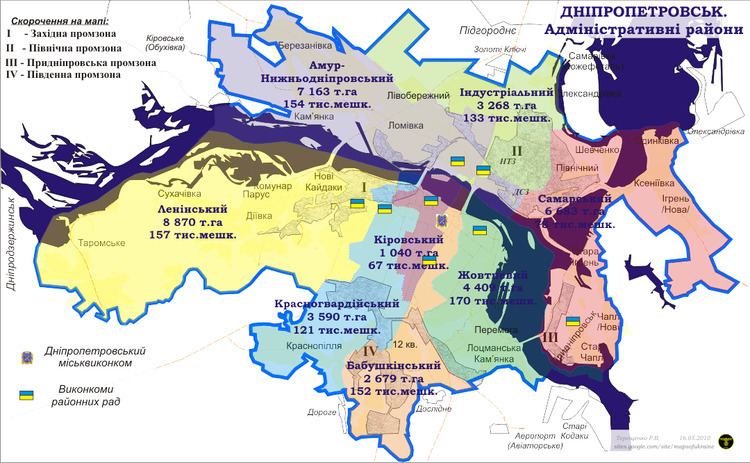
Amur-Nyzhnodniprovskyi District (Ukrainian: Амур-Нижньодніпровський район; sometimes abbreviated as "AND") is an urban district of the city of Dnipropetrovsk, in southern Ukraine. It is located on the city's north and on the left-bank of Dnieper River along with the city's Industrialnyi and Samarskyi districts. Its name is derived from a small settlement of Amur and the Nyzhnodniprovsk railway station.
Contents
Map of Amur-Nyzhn'odniprovs'kyi district, Dnipropetrovsk, Dnipropetrovska, Ukraine
History
Previously the territory was known locally as Trans-Dnieper region (Zadniprovia) and belonged to the Samara province (palanka) of Zaporizhian Sich. After liquidation of Zaporizhian Sich by the Russian government of Catherine the Great in 1775, the region was admitted into the newly formed Novomoskovsk county of Yekaterinoslav Governorate.
In September 1917 all settlements of Trans-Dnieper were united into a district of Zadniprovskyi Raion. On 25 January 1918 the district was transformed into the town of Amur-Nyzhnodniprovsk which sometime before 1920 was merged with Katerynoslav as one of its five urban districts. In 1969 the district was split in half and at its eastern and northern portions was created the Industrialnyi District of Dnipropetrovsk.