
PIN 814111 (Amrapara) Elevation 146 m | Time zone IST (UTC+5:30) Telephone/STD code 06427 Area code 06427 | |
 | ||
Amrapara is a community development block that forms an administrative division of Pakur district, Jharkhand state, India. It is located 36 km from Pakur, the district headquarters.
Contents
- Map of Amrapara Jharkhand
- Geography
- Demographics
- Literacy
- Predominantly agricultural district
- Coal mining
- References
Map of Amrapara, Jharkhand
Geography
Amrapara, the eponymous CD Block headquarters, is located at 24°31′0″N 87°34′29″E.
Amrapara CD Block covers an area of 273.29 km2 and has 10 panchayats, 121 inhabited (chiragi) villages and 2 uninhabited (bechiragi) villages.
Demographics
As per 2011 Census of India, Amrapara CD Block had a total population of 65,289, all of which were rural. There were 32,923 (50%) males and 32,366 (50%) females. Population below 6 years was 12,785. Scheduled Castes numbered 1,572 and Scheduled Tribes numbered 53,623.
In 2011, Amrapara (village) had a population of 3,898 and Amrapara Bazar (village) had a population of 1,430.
In 2001 census, Hindus constituted 64.59%, Christians 7.20% and Muslims 3.1% of the population in Amrapara CD Block. In the district as a whole Hindus constituted 44.45%, Muslims 32.74% and Christians 6.01% of the population. The percentage of scheduled tribes in the population of Amrapara CD block was 81.60%. In the district as a whole scheduled tribes constituted 44.59% of the population. Around 85% of the tribal population was composed of Santhals. There are two primitive groups – Mal Paharias and Sauria Paharias.
Literacy
As of 2011 census, the total number of literates in Amrapara CD Block was 24,442 (46.55 % of the population over 6 years) out of which 14,856 (61 %) were males and 9,586 (39 %) were females.
As of 2011 census, literacy in Pakur district was 48.82.Literacy in Jharkhand (for population over 7 years) was 66.41% in 2011.Literacy in India in 2011 was 74.04%.
Predominantly agricultural district
Pakur is predominantly a hilly district. There is a narrow fertile alluvial tract bordering the Ganges Feeder Canal. While the hills stretch from the north to the south-east, the rest is rolling area, which is less conducive to agricultural operations than the alluvial strip. The net sown area of the district is around 28%. Thus though the district is predomnantly agricultural it offers only limited opportunities to the people. Many people from the district migrate to the neighbouring districts of West Bengal during the agricultural seasons.
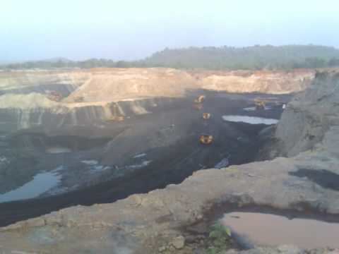
Coal mining
In Amrapara circle, Eastern Coalfields Limited operated Chilgo and other collieries, which are part of Rajmahal coalfield. Panem Coalmines Private Limited operates collieries at Singdehri and nearby places. The latter mine feeds coal to the Punjab State Electricity Board power plants.Pachwara colliery with a capacity of 7 million tonnes per year is located near Amrapara village in Bansloi River valley.