
Area 1.6 ha (4.0 acres) | ||
 | ||
engsub vietsub l n o an bang amboyna cay spratly islands vietnam
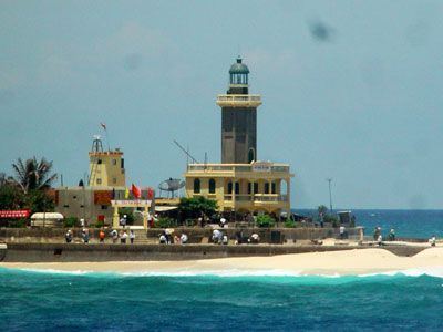
Amboyna Cay or An Bang Island (Tagalog: Lagos; Chinese: 安波沙洲; pinyin: Anbo Shazhou; Vietnamese: Đảo An Bang; Malay: Pulau Amboyna Kecil) is an island of the Spratly Islands group in the South China Sea. With an area of 1.6 hectares, it is the thirteenth largest Spratly island and the sixth largest among the Vietnamese-occupied Spratly islands.
Contents
- engsub vietsub l n o an bang amboyna cay spratly islands vietnam
- Map of Amboyna Cay
- Recent history
- References
Map of Amboyna Cay
The island has two parts: the east part consists of sand and coral, and the west part is covered with guano. It has a fringing reef. An obelisk, about 2.7 m high, stands on the SW corner. There is little vegetation. It is described by some as heavily fortified. A lighthouse has been operational on the island since May 1995.
The island is also claimed by the People's Republic of China, the Republic of China (Taiwan), the Philippines and Malaysia.
Recent history
On 1978, the Royal Malaysian Navy landed on the island and placed markers. However, the markers were subsequently destroyed by Vietnam who now occupies the island.
On March 31, 1979, forces occupying the Cay fired warning shots on a boat transporting six Amateur radio operators ("hams') attempting a Dxpedition to Amboyna Cay.
In 1982, a Singapore yacht operated by the owner and his wife transporting four German hams on a DXpedition to Amboyna Cay was fired upon by Vietnamese forces. One of the hams, Diethelm Mueller, was hit by an artillery round and fell overboard. The yacht burned and the rest of the party drifted for 11 days on debris. Another ham, Gero Band, died of thirst the day before the survivors were rescued by a passing Japanese freighter which took them to Hong Kong.