
Department Aisne Population 1,112 (1999) | Area 17.32 km² Local time Tuesday 6:36 AM | |
 | ||
Intercommunality Pays de la Vallée de l'Aisne Weather 5°C, Wind SW at 29 km/h, 82% Humidity | ||
Visite express d ambleny d hygni res au donjon
Ambleny is a French commune in the department of Aisne in the Hauts-de-France region of northern France.
Contents
- Visite express d ambleny d hygni res au donjon
- Map of 02290 Ambleny France
- Course cadets ambleny 2016
- Geography
- History
- Administration
- Demography
- Distribution of age groups
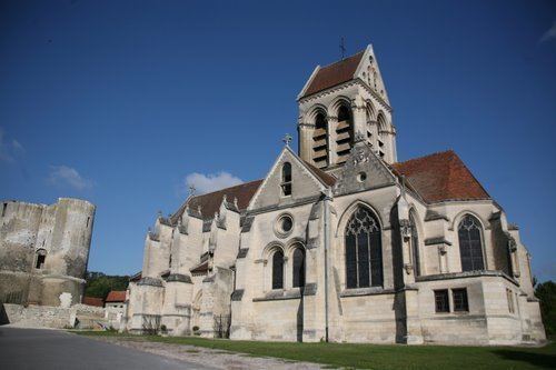
- Sites and monuments
- Notable people linked to the commune
- References
Map of 02290 Ambleny, France
The inhabitants of the commune are known as Amblenois or Amblenoises
Course cadets ambleny 2016
Geography
Ambleny is located 8 km west of Soissons and 20 km east of Compiegne. Route National N31 passes through the northern part of the commune between those two cities with an exit to the D943 road which runs south to the town. The D17 road also runs from Fontenoy in the north to the town then continues south to Coeuvres-et-Valsery. The D1631 road also runs from the town south-east to join the D94 road at the southern tip of the commune. There are a number of hamlets in addition to the town - these are: Le Soulier, Montaigu, Hignieres, and Le Rollet. The northern part of the commune is mixed forest and farmland while the southern portion is entirely farmland.
The Ru de Retz waterway forms part of the south-western boundary of the commune before flowing north through the town and continuing to the Aisne river just north of the commune as it flows west to join the Oise at Compiegne. The Quenneton stream joins the Ru de Retz south of the town at the commune boundary from the west.
History
The former hamlets of Fosse-en-Haut and Fosse-en-Bas served as the starting point for several French units (including the 418th Infantry Regimanet) during the Second Battle of the Marne on 18 July 1918.
Administration
List of Mayors of Ambleny
(Not all data is known)
Demography
In 2010 the commune had 1,134 inhabitants. The evolution of the number of inhabitants is known through the population censuses conducted in the town since 1793. From the 21st century, a census of municipalities with fewer than 10,000 inhabitants is held every five years, unlike larger towns that have a sample survey every year.
Sources : Ldh/EHESS/Cassini until 1962, INSEE database from 1968 (population without double counting and municipal population from 2006)
Distribution of age groups
Percentage distribution of age groups in Ambleny and Aisne Department in 2007
Sources: