
Easiest route Zojila side North face | First ascent Never been climbed Elevation 5,186 m | |
 | ||
Similar Machoi Peak, Kolahoi Peak, Tatakooti Peak, Harmukh, Nun Kun | ||
Amarnath Peak is a mountain with a peak elevation of 5,186 metres (17,014 ft), in Ganderbal district of Kashmir, in the vicinity of Sonamarg. Amarnath Peak is part of the Himalayas, and is located south of Zojila and west of Machoi Glacier. It lies 117 km northeast from Srinagar, 13 km from Baltal in the southeast. It lies 6 km south of Zojila. The melt waters form a major tributary of the Sind River at Baltal.
Contents
Map of Amarnath Peak, 194102
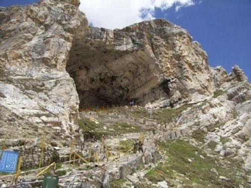
Amarnath mountain is considered as a sacred mountain, it has a cave at its south face at an elevation of 3,800 metres (12,470 ft) known as Amarnath cave. The cave is believed to be the ancient and among most sacred places for pilgrimage in Hinduism. It is the centre for Hindu pilgrims during summer.
Climbing history and routes
Amarnath Peak is among the peaks which stands unclimbed, due to its sacredness. It was first surveyed by a British medical team headed by Dr Ernest Neve in 1912, who surveyed most of the peaks of this Himalayan range A Scottish Colonel N. N. L. Watts also went through the tracks of this peak and discovered an easy route to ascend the peak in 1933, which leads from Zojila down towards south and a glacial ascend will bring to the summit of Amarnath Peak.
Apart from Zojila side, Amarnath Peak can be climbed leaving cave on left side and climb through east face. The easiest route as discovered by Colonel N. N. L.Watts is from the north face which is accessible from Srinagar 112 kmd by road NH 1D, 12 km from Sonamarg and 4 km glacial ascend leads to the glacier of the peak .