
Listing Ultra Elevation 5,995 m Parent range Cordillera Occidental | Location Bolivia – Chile border Prominence 1,733 m | |
 | ||
Similar Irruputuncu, Isluga, Cerro Capurata, Putana Volcano, Tata Sabaya | ||
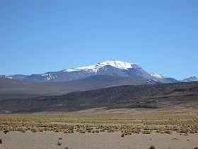
Alto Toroni (Cerro Sillajguay) is a mountain in South America. It is 5,995 metres (19,669 ft) tall and sits on the international border between Bolivia and Chile.
Contents
The mountain is of volcanic nature and has had recent ground deformation and seismic activity. Heavy glacial activity has affected the mountain's shape, and some glaciation persists until today.
Geography
Alto Toroni is the highest mountain in the Andes between 19 and 21° degrees south. The volcano is surrounded by other volcanoes and rises about 2,000 metres (6,600 ft) above the surrounding plain. The volcano has the shape of a Y with ridges pointing northeast, southeast and west. Cerro Carvinto (5,060 metres (16,600 ft)) is a subsidiary peak southwest of the main summit. Picavilque and Kimsa Chata are neighbours of this volcano. The volcano is located in the Pica gap, a territory of decreased Holocene volcanism between Irruputuncu and Isluga volcanoes, on the western edge of an Oligocene or Quaternary volcanic field named Serranía Intersalar. The local erosion level comprising Salar de Uyuni and Salar de Coipasa rises up to the massif that is median 5,030 metres (16,500 ft) high and is incised by deep gorges.
The area is part of the summer rain zone of the Atacama; the mountain displays a highly diurnal temperature cycle and frost-thaw effects. Precipitation is assumed to be 200 millimetres (7.9 in) at 4,500 metres (14,800 ft) altitude and 300–400 millimetres (12–16 in) at 5,000 metres (16,000 ft). Runoff runs towards the east. The area is subject to heavy insolation.
On the southern and eastern side, valleys and dry streams have dendritic systems, while in the north and west parallel valleys prevail. The Rio Blanco, the Ricon Tacurma, the Quebrada Seca and the Quebrada Quisimachir are the only streams carrying water at all times; other channels are active only during snowmelt and rainfall.
Cancosa 16 kilometres (9.9 mi) southeast and Villa Blanca are the closest human habitations to the volcano with a few hundred indigenous inhabitants; Cancosa also has a military post. Land roads connect these to the larger town Pica that is five hours away.
Geology
Lava flows from the volcano are well preserved and extend radially into Bolivia.
Lavas are of dacitic composition and one hornblende-biotite dacite in the Cueva Colorada sector has been potassium-argon dated at 3.4 mya. The dacites contain phenocrysts of biotite and large feldspar crystals embedded in an oxidized groundmass. Some rocks are altered and have been affected by glacial action. Solfataric deposits are found on the volcano. The volcano has been subject to strong glacial denudation.
Evidence of ongoing volcanic activity includes local seismic activity and deformation, including a pulse between 2007 and 2010. This deformation is inferred to originate at 16 kilometres (9.9 mi) depth and may be of axisymmetric or less likely dyke shape. 25 kilometres (16 mi) southwest of the Sillajguay chain is the Pampa Lirima geothermal field.
Glaciation
Breaking blocks, firn and patterned or striated ground occupy small areas. In some valleys rock glaciers cover up to 5% of the surface area in some valleys. A major, active 500 metres (1,600 ft) long block glacier lies in the Rincon Tucuruma valley, with a tongue 60 metres (200 ft) high. Smaller block glaciers lie on the sides of the Quebrada Seca, at an altitude of 5,200–5,350 metres (17,060–17,550 ft). Firn with penitentes has been found just southwest below the summit area, likely the remains of a glacier.
The volcano was formerly much more strongly glaciated, with glaciers 11 kilometres (6.8 mi) long on the north side and 7–8 kilometres (4.3–5.0 mi) on the south side of the mountain. Moraines have been found at a lowest altitude of 4,240 metres (13,910 ft), with higher ones at 4,460 metres (14,630 ft) and 4,520 metres (14,830 ft). All major valleys are through valleys due to glacial deepening.
Global warming caused a decrease of the surface area of the glacier by 54% between 1989 and 2011 after temperature increases of 2 °C (36 °F). Some minor expansion has occurred after El Nino events. Continuing warming may lead to a reduction of the glacier's area by 50% by 2030.
Flora and Fauna
Vegetation cover is scarce in the area and is dominated by grasses and shrubs and isolated Polylepis trees. According to local reports, Puma burrows are found on the heights of the volcano.