
Isolation 1.4 km → Saubuckelkopf Elevation 2,177 m | First ascent by locals Prominence 172 m | |
 | ||
Similar Roßgundkopf, Griesgundkopf, Linkerskopf, Wildengundkopf, Fürschießer | ||
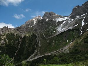
The Alpgundkopf is a mountain, 2,177 m high, in the Allgäu Alps. It lies in the Schafalpenköpfe group, northeast of the Roßgundkopf, from which it is separated by the Alpgundscharte col. To the southeast, 383 metres away, lies the lower Alpkopf and, 1,035 metres away, the small lake of Guggersee.
Contents
Map of Alpgundkopf, 87561 Oberstdorf, Germany
AscentEdit
There are no waymarked paths up the Alpgundkopf. The normal approach is a trackless route from the notch of Alpgundscharte that requires sure-footedness and mountain experience. All other ascents are not recommended due to the brittle nature of the rock.
LiteratureEdit
References
Alpgundkopf Wikipedia(Text) CC BY-SA