
County Park County Named for Alma James Elevation 3,158 m Zip code 80420 Local time Sunday 8:59 AM | State Colorado Incorporated 1873-12-02 Time zone MST (UTC-7) Area 94 ha Population 267 (2013) Area code 719 | |
 | ||
Weather -12°C, Wind W at 26 km/h, 33% Humidity | ||
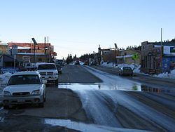
North america s highest incorporated town alma colorado
Alma is a Statutory Town located in Park County, Colorado, United States. The town population was 270 at the 2010 United States Census.
Contents
- North america s highest incorporated town alma colorado
- Map of Alma CO USA
- Geography
- Demographics
- Climate
- Mines
- References
Map of Alma, CO, USA
At an elevation of approximately 10,578 feet (3,224 m), it is the highest incorporated municipality in the United States with permanent residents. Alma, which is a town, did not take the title as highest incorporated city from Leadville, Colorado, as is commonly believed. Leadville is still the highest incorporated city in North America. Using administrative boundaries as a measure, not settled areas, in 2006 Winter Park, Colorado became the highest incorporated town due to its annexation of a ski area. Alma, however, has a contiguous residential area (on Mountain View Drive) extending to 11,680 feet (3,560 m) above sea level, while any such area in or near Winter Park reaches only 9,550 feet (2,910 m), Leadville 10,360 feet (3,160 m).
The town was named by a merchant named Mr. James, after his wife. Another tradition states the town was named for the daughter of a resident.
Geography
Alma is located at 39°17′03″N 106°03′48″W, along State Highway 9.
According to the United States Census Bureau, the town has a total area of 0.362 square miles (0.94 km2), almost all of it land.
Demographics
As of the census of 2000, there were 179 people, 94 households, and 40 families residing in the town. The population density was 523.6 people per square mile (203.3/km²). There were 147 housing units at an average density of 430.0 per square mile (166.9/km²). The racial makeup of the town was 92.74% White, 2.23% Native American, 0.56% Asian, 3.35% from other races, and 1.12% from two or more races. Hispanics or Latinos of any race were 3.35% of the population.
There were 94 households, of which 18.1% had children under the age of 18 living with them, 37.2% were married couples living together, 2.1% had a female householder with no husband present, and 57.4% were non-families. 39.4% of all households were made up of individuals and 1.1% had someone living alone who was 65 years of age or older. The average household size was 1.90 and the average family size was 2.63.
The age distribution was 12.8% under the age of 18, 5.6% from 18 to 24, 53.1% from 25 to 44, 24.0% from 45 to 64, and 4.5% who were 65 years of age or older. The median age was 37 years. For every 100 females there were 132.5 males. For every 100 females age 18 and over, there were 140.0 males.
The median income for a household in the town was $41,563, and the median income for a family was $59,688. Males had a median income of $28,750 versus $26,563 for females. The per capita income for the town was $25,165. None of the families and 4.3% of the population were living below the poverty line.
Climate
Alma's climate is subarctic (Dfc) and closely borders on an alpine climate with July average of 10.9 C.
Mines
Approximately two miles from Alma are the remains of the defunct Orphan Boy mine (founded 1861), which produced gold, silver, lead, and zinc over a number of decades.
The historic Sweet Home Mine near Alma, formerly a silver mine, now produces spectacular rhodochrosite mineral specimens.