
Chinese 阿里山國家風景區 Phone +886 5 267 9971 | Province Taiwan Province | |
 | ||
Hanyu Pinyin Hokkien POJ A-lí-san Kok-ka Hong-kéng-khu Address 605, Taiwan, Chiayi County, Alishan Township, 中正村59號 Similar Sun Moon Lake, Alishan Station, Zhushan Station, Shenmu Station, Alishan Range Profiles | ||
The Alishan National Scenic Area is a mountain resort and natural preserve located in the mountains of Chiayi County in Taiwan.
Contents
- alishan national scenic area taiwan
- Geography
- Climate
- Topography
- Vegetation and wildlife
- History
- Attractions and landmarks
- References
alishan national scenic area taiwan
Geography
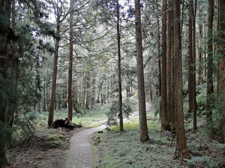
Alishan is 415 square kilometres (41,500 ha) in area. Notable characteristics include mountain wilderness, four villages, waterfalls, high altitude tea plantations, the Alishan Forest Railway, and a number of hiking trails. The area is popular with tourists and mountain climbers. Alishan, or Mount Ali, itself has become one of the major landmarks associated with Taiwan. The area is famous for its production of high mountain tea and wasabi.
Alishan is well known for its sunrises, and on a suitable morning one can observe the sun come up on a sea of clouds in the area between Alishan and Yüshan. Alishan and Sun Moon Lake are two of the best known scenic spots in Asia. The indigenous people of the area, the Thao people, have only recently been recognized as a discreet ethnic group. They have long been confused with the Tsou people.
Climate
Alishan National Scenic Area spans a broad range in altitude. Lower elevations, such as in Leye Township, share the same subtropical and tropical climate as the rest of southern Taiwan, while the climate changes to temperate and alpine as the elevation increases. Snow sometimes falls at higher elevations in the winter.
Alishan National Scenic Area covers most, but not all, of Alishan Rural Township in Chiayi County, as well as parts of neighboring townships in Taiwan.
Average temperatures are moderate:
Topography
Alishan is mountainous:
Vegetation and wildlife
Important trees in the area include:
History
The Alishan area was originally settled by the Tsou tribe of the Taiwanese aborigines; the name derives from the aboriginal word Jarissang. Ethnic Han Chinese settlers first settled on the plains near modern-day Chiayi as early as the late Ming Dynasty (around the mid-17th century), but did not move into the mountains until the late 18th century, establishing the towns of Ruili (瑞里), Ruifeng (瑞峰), Xiding (隙頂), and Fenqihu (奮起湖). The resulting armed clashes between the settlers and the aborigines pushed the aborigines even further into the mountains.
Following the cession of Taiwan to Japan at the end of the First Sino-Japanese War, Japanese expeditions to the area found large quantities of cypress (檜木, or hinoki in Japanese). This led to the development of the logging industry in the area and the export of local cypress and Taiwania wood. A series of narrow-gauge railways were built in the area during this time to facilitate the transportation of lumber from the mountains to the plains below, part of which continues to operate as the Alishan Forest Railway. Several new villages also began to sprout up along the railway lines. It was also during this time that the first tourists began to visit the area. Plans were even drawn up to incorporate the area into the new Niitaka (New Highest) Arisan National Park (新高阿里山国立公園).
With the exhaustion of forest resources by the 1970s, domestic and international tourism overtook logging to become the primary economic activity in the area. The tourism industry continued to expand with the completion of the Alisan highway in the 1980s, displacing the railroad as the primary mode of transportation up the mountain. To combat the problems associated with the growing crowds of tourists and the expanding tea and wasabi plantations, the area was declared a national scenic area in 2001.
On 1 December 2014, fire broke out at Alishan spreading over more than 5 hectares of land. The area affected was located near Tapang No. 3 Bridge. The fire was believed to happen due to dry ground which was vulnerable to fire because of the absence of rain in the area for months.
Attractions and landmarks
Fenqihu (奮起湖) is a small town of low wooden buildings built into the mountainside at 1,400 meters, midpoint of the Alishan Forest Railway. It is famous for natural rock formations, mountain streams, forests, and the ruins of a Shinto temple in the vicinity, as well as for its production of high altitude food products such as bamboo shoots and aiyu jelly (愛玉). The local box lunches (奮起湖便當, Fenqihu bento), which were once sold to passengers on the rail line, are also well known.