
Area 34.4 km² | Canton Montagne Basque Population (2014) 227 | |
 | ||
D tection de fuite par fluoresc ine al ay al ab h ty sunharette
Alçay-Alçabéhéty-Sunharette (Basque: Altzai-Altzabeheti-Zunharreta) is a commune in the Pyrénées-Atlantiques department in the Nouvelle-Aquitaine region in southwestern France.
Contents
- D tection de fuite par fluoresc ine al ay al ab h ty sunharette
- Map of 64470 AlC3A7ay AlC3A7abC3A9hC3A9ty Sunharette France
- Beton imprime al ay al ab h ty sunharette france www betonimprimeart fr youtube
- Location
- Access
- Hydrography
- Toponymy
- History
- Administration
- Inter communality
- Before 1833
- From 1793 to present
- Economy
- Civil heritage
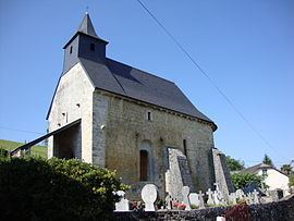
- Religious Heritage
- Environmental heritage
- References
Map of 64470 Al%C3%A7ay-Al%C3%A7ab%C3%A9h%C3%A9ty-Sunharette, France
Beton imprime al ay al ab h ty sunharette france www betonimprimeart fr youtube
Location
Alçay-Alçabéhéty-Sunharette is located in the former province of Soule. It is located some 35 km west by south-west of Oloron-Sainte-Marie and 10 km north of Larrau.
Access
The commune can be accessed by the small D247 road from the village to Tardets-Sorholus in the north-east. The D149 branches off this road in the commune and goes north to Camou-Cihigue. There is also the D117 road which goes west from the village to Mendive.
Hydrography
Located in the drainage basin of the Adour, most of the southern border of the commune is formed by the Alphoura river (18 km long) which also flows through the village and continues northeast to join the Saison near Alos-Sibas-Abense. The Alphoura is fed by many tributaries rising in the commune including the Azaléguy and Ardounc. The Escalérako erreka rises in the south and flows west with its many tributaries.
Paul Raymond mentioned the Arangaïxa, a brook that rises at Alçay and flows into the Alphoura.
Toponymy
The commune name in Basque is Altzai-Altzabeheti Zünharreta.
According to Jean-Baptiste Orpustan, the base (h)altz meaning "aulne" was used for the both toponyms Alcay and Alçabéhéty. beheti means "at the bottom".
The name Sunharette comes from the Basque zunharr (Name from Soule meaning "elm" or "poplar") using the romanized locative suffix ette meaning the "place of elm".
The following table details the origins of the commune name and other names in the commune.
Sources:
Origins:
History
In 1790 Sunharette was the chief town of a canton which was part of the District of Mauleon. The canton included the communes of Alçay-Alçabéhéty-Sunharette, Alos-Sibas-Abense, Camou-Cihigue, Etchebar, Lacarry-Arhan-Charritte-de-Haut, Lichans-Sunhar, and Ossas-Suhare.
In 1833, the three communes of Alçay, Alçabéhéty, and Sunharette merged to form a single joint commune.
Administration
List of Successive Mayors
(Not all data is known)
Inter-communality
The town is part of seven intercommunal organisations:
Before 1833
Population split between 3 Communes
From 1793 to present
In 2009 the commune had 228 inhabitants. The evolution of the number of inhabitants is known through the population censuses conducted in the commune since 1793. From the 21st century, a census of communes with fewer than 10,000 inhabitants is held every five years, unlike larger towns that have a sample survey every year.
Sources : Ldh/EHESS/Cassini until 1962, INSEE database from 1968 (population without double counting and municipal population from 2006)
Economy
Activity is mainly focused on agriculture (livestock and pasture). The town is part of the Appellation d'origine contrôlée (AOC) zone of Ossau-iraty.
According to the 2006 classification of INSEE, showing the median household incomes for all communes with more than 50 households (30,687 communes out of the 36,681 communes identified) Alçay-Alçabéhéty-Sunharette is ranked 20,901st with an average income of €14,927 per year.
Civil heritage
The commune has two sites that are registered as historical monuments: