
• Density 51/km (130/sq mi) • Total 8,357 Local time Saturday 7:51 AM Name Agira Agira | Elevation 650 m (2,130 ft) Area 163.1 km² Postal code 94011 | |
 | ||
• Total 163.11 km (62.98 sq mi) Weather 4°C, Wind N at 8 km/h, 88% Humidity | ||
Agira canadian war cemetery july 30th 2013
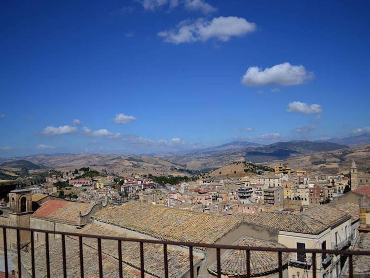
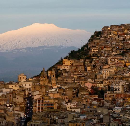
Agira ([aˈdʒiːra]; Sicilian: Aggira) is a town and comune in the province of Enna, Sicily (southern Italy). It is located in the mid-valley of the River Salso, 35 kilometres (22 miles) from Enna. Until 1861 it was called San Filippo d'Argiriò, in honour of its saint Philip of Agira.
Contents
- Agira canadian war cemetery july 30th 2013
- Operation husky 2013 agira
- Geography
- History
- Main sights
- Economy
- Transportation
- International relations
- References
Operation husky 2013 agira
Geography
Agira is 141 kilometres (88 mi) from Agrigento, 69 kilometres (43 mi) from Caltanissetta, 66 kilometres (41 mi) from Catania, 34 kilometres (21 mi) from Enna (to whose province it belongs), 162 kilometres (101 mi) from Messina, 184 kilometres (114 mi) from Palermo, 144 kilometres (89 mi) from Ragusa, 124 kilometres (77 mi) from Siracusa, and 291 kilometres (181 mi) from Trapani.
The Pozzillo artificial lake lies near the town in a eucalyptus wood, and provides a habitat for a large variety of birds, and a way-stage for migrators. Another reserve – the Riserva di Piano della Corte – has been created in the Erean Mountains, and the Mediterranean forest of the Vallone di Piano della Corte is scheduled to become another reserve. The area also contains sulphur springs.
History
Agira stands on the site of the ancient Sicel city of Agyrion (Ancient Greek: Ἀγύριον - Agyrion), or Agyrium, which was ruled by tyrants, one of whom, Agyris, was the most powerful ruler in the centre of Sicily. He was a contemporary of Dionysius the Elder, and with him successfully resisted the Carthaginian forces led by Mago when they invaded the territory of Agyrium in 392 BC. Agira was not colonised by the Greeks until the Corinthian general Timoleon drove out the last tyrant in 339 BC, settled 10,000 Greeks, according to Diodorus Siculus, a native of the city, and erected various splendid buildings; no traces remain, as the modern city overlies the ancient one.
Diodorus Siculus credits Heracles with the foundation of sacred precincts of Iolaus and of Geryon, and the creation of a nearby lake. In the mid fifth century, Agyrium was the first Sicilian city to mint bronze coinage in the Greek fashion.
The Romans called it Agirium. Under their control it underwent a decline, as a result of the heavy taxation imposed on it. In 1063, it was taken by the Normans under Count Roger I of Sicily (Ruggero in Italian), who defeated the Saracens near the river Salso. Agira is mentioned by Muhammad al-Idrisi by the name Shanta Fīlibb (i.e., Saint Philip of Agira), written as شنت فيلب in the Arabic script.
Agira passed through the hands of the Hohenstaufen, the Angevines and Aragonese, and in about 1400 it became state property of Sicily. Over the years the town has been influenced by Spanish and Jewish arrivals, both leaving their architectural mark, the latter a synagogue.
Main sights
The main buildings of note are its numerous churches, most of which contain collections of art works. They include the Norman Chiesa Madre ("Mother Church") dedicated to Santa Maria Maggiore, the Norman church of Santa Margherita, which is the largest in the diocese, with thirteen altars, and which dates from the early 13th century (though it has been much changed since then), the church of St Filippo, which has a nave and two aisles, and contains paintings by Olivo Sozzi, the 16th-century church of Sant'Antonio da Padova, which also has three naves, the 16th-century church of Sant'Antonio Abate, containing fourteen small paintings of the Venetian school, and the church of San Salvatore, with Gothic bell-tower.
There is also an Arab–Byzantine castle, later rebuilt by the Hohenstaufen, of which two towers still stand.
Economy
The town is a centre of agriculture: productions include cereals, almonds, olives, and grapes. The large areas of pasture also make possible the breeding of cattle, sheep, and horses.
Transportation
There is a railway station south of the town.
International relations
Agira is twinned with: