
Length 0.9 mi (1.4 km) | Major cities London | |
 | ||
Location St. John's Wood, London, England, UK East end Grove End Road, St. John's Wood Similar | ||
Abbey road london uk
Abbey Road is a thoroughfare in the borough of Camden and the City of Westminster in London, running roughly northwest to southeast through St. John's Wood, near Lord's Cricket Ground. It is part of the B507 road. This road is best known for the Abbey Road Studios and the 1969 album, Abbey Road, by The Beatles.
Contents
- Abbey road london uk
- Map of Abbey Rd London NW6 4DN UK
- The beatles abbey road london
- Location
- History
- References
Map of Abbey Rd, London NW6 4DN, UK
The beatles abbey road london
Location
The north-western end of Abbey Road begins in Kilburn, at the junction with Quex Road and West End Lane. The road was once a track leading to Kilburn Priory and its associated Abbey Farm, and was developed in the early 19th century. It continues south-east for roughly a mile, crossing Belsize Road, Boundary Road, and Marlborough Place, ending at the junction of Grove End Road and Garden Road.
History
The Abbey National Building Society (now Santander UK) was founded in 1874 as The Abbey Road & St John's Wood Permanent Benefit Building Society in a Baptist church on Abbey Road.
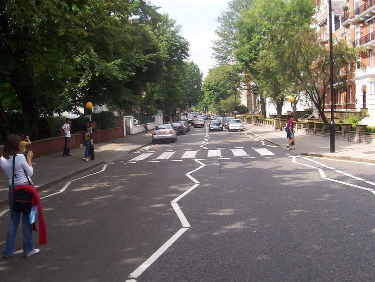
EMI's Abbey Road Studios are located at the south-eastern end, at 3 Abbey Road, St John's Wood. The Beatles and many other famous popular music performers have recorded at this studio, and The Beatles named their last studio LP after this street. The album's cover photograph shows the four group members walking across the zebra crossing just outside the studio entrance. As a result of its association with The Beatles, since 1969 this part of Abbey Road has been featured on the London tourism circuit. In December 2010 the crossing was given Grade II Listed Building status by English Heritage despite its age not being contemporary to that era.
The zebra crossing featured on the Beatles cover, as well as the crossing directly north of it, have become popular photo-opportunity areas, despite the road still being a busy thoroughfare for traffic. The iconic Beatles album cover has been parodied many times over the years on the crossing.
The tin street sign on the corner of Grove End Road and Abbey Road is now mounted high on the building on the corner, to save the local council the expense of cleaning and replacing the sign, which was frequently defaced and stolen. The council repaints the wall next to the zebra crossing every three months to cover fans' graffiti.
Abbey Road is also a ward of the City of Westminster. At the 2011 Census this ward had a population of 11,250.