
Population 424 (2011) Civil parish Abberton Local time Tuesday 6:42 AM | OS grid reference TM007190 Sovereign state United Kingdom Dialling code 01206 | |
 | ||
Weather 2°C, Wind W at 19 km/h, 89% Humidity | ||
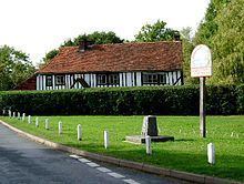
Abberton is a village in Essex, England. It is located approximately 0.62 mi (1.00 km) east of Abberton Reservoir and is 4.2 mi (6.8 km) south of Colchester. The village is in the borough of Colchester and in the parliamentary constituency of North Essex. The town is served by Abberton and Langenhoe Parish Council.
Contents
Map of Abberton, Colchester, UK
There is a post office in the village.
Abberton is recorded in the Domesday Book of 1086-87 as Edburghetuna and as Edburgetuna in the Hundred of Winstree, when it was part of the lands of Count Eustace in Essex, held by Ralph de Marcy and further held by Ranulf Peverel in demesne; it was held by Siward, a free man, as a manor in the time of King Edward before the Norman conquest of 1066.
Abberton is among the villages which suffered damage from the 1884 Colchester earthquake.
Church
The Church at Abberton is St Andrew. It is located at the end of Rectory Lane approximately three hundred yards from Abberton Reservoir.