
Interest Biological Area 4.9 km² Mean depth 5.25 m | Grid reference TL970180 Location map Magic Map Surface elevation 18 m Year built 1939 Notification 1988 | |
 | ||
Abberton reservoir
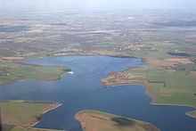
Abberton Reservoir is an artificial body of water located close to the coast of Essex in the east of England. It is 5 miles (8.0 km) south-west of Colchester near the village of Layer de la Haye. The reservoir is the fourth largest reservoir in England with an area of 4.9 square kilometres (1,200 acres). It is a Site of Special Scientific Interest,and also a Ramsar site, designated an internationally important wetland. It is a Special Protection Area, and it is listed in the Nature Conservation Review. A small part of the site is managed by the Essex Wildlife Trust.
Contents
Map of Abberton Reservoir, Colchester, UK
It is a large, shallow, freshwater storage reservoir and is the largest freshwater body in Essex.
The reservoir contains around 25,000 megalitres (5.5×10⁹ imp gal). It is a pumped storage reservoir. This means water is pumped from the rivers Chelmer, Blackwater and Stour to fill it, rather than simply relying on rainfall in the limited catchment area. The reservoir was formed by damming a shallow river valley. Plans to increase the capacity of Abberton reservoir to 41,000 megalitres (9.0×10⁹ imp gal) by raising its bank height. were completed in 2015.
On its margins are found well-established plant communities that provide important opportunities for feeding, nesting and shelter. Abberton Reservoir is important as an autumn arrival area for waterbirds that then spend the winter elsewhere.
It was designated a Special Protection Area on 5 December 1991 as a result of its over-wintering populations of golden plover, gadwall, shoveler and teal and for its breeding population of cormorants. In addition there are significant numbers of black-tailed godwit, lapwing, coot, goldeneye, tufted duck, pochard, pintail, wigeon and great crested grebe.
The Reservoir was used by the RAF's 617 Squadron ("The Dam Busters") for practice runs for the bombing of the German dams in the Ruhr during World War II (Operation Chastise) . Wing Commander Guy Gibson, the leader of the raid, referred to it as "Colchester Lake" in his auto-biography Enemy Coast Ahead. The reservoir was similar in shape to that of the Eder Dam in Germany which was attacked after the Möhne Dam had been breached. The Layer Causeway, from which the photograph was taken, was used as a substitute for the Eder Dam. Military police closed the causeway whilst the practice runs took place. Lancaster bombers fitted with special bouncing bombs designed by Barnes Wallis were used [source?]. The last practice flight to Abberton was a full dress rehearsal of the attack and took place on the night of May 14, 1943; the attack on the dams in Germany took place on the night of May 16, 1943.
The site has a visitor centre on Church Road in Layer-de-la-Haye.