
Elevation 11,360 ft (3,460 m) Country United States of America | Highest point Abajo Peak | |
 | ||
Similar Abajo Peak, Indian Creek, Moab Golf Club, Henry Mountains, Canyonlands National Park Nee | ||
Utah general season deer hunt 2016 san juan abajo mountains
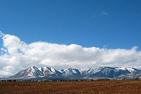
The Abajo Mountains, known locally as the Blue Mountains or The Blues, is a small mountain range west of Monticello, Utah, south of Canyonlands National Park and north of Blanding, Utah. The mountain range is located within the Manti-La Sal National Forest. The highest point within the range is Abajo Peak at 11,360 feet (3,463 m).
Contents
- Utah general season deer hunt 2016 san juan abajo mountains
- Map of Abajo Mountains Utah 84535 USA
- Utah general season deer hunt 2015 san juan abajo mountains
- References
Map of Abajo Mountains, Utah 84535, USA
This mountain range, like both the La Sal Range and Henry Mountains in the same part of the Colorado Plateau, is formed about igneous intrusions that are relatively resistant to erosion. Some of these intrusions form laccoliths emplaced at depths of a few kilometers. The predominant igneous rock is porphyritic hornblende diorite. Ages of intrusion in the Abajo Mountains fall in the interval from 22 to 29 million years.
These mountain ranges are part of the Colorado Plateau province west of the greater ranges of the Rocky Mountains. The laccolith ranges are much younger and have a very different geologic origin.
The range was reputedly named by the Spanish in the 1700s, the name "Abajo" meaning "low".