Supriya Ghosh (Editor)

A85 autoroute

Updated on
Edit
Like
Comment
Share on FacebookTweet on TwitterShare on LinkedInShare on Reddit
Length
  
206 km

Highway system
  
Autoroutes of France

A85 autoroute

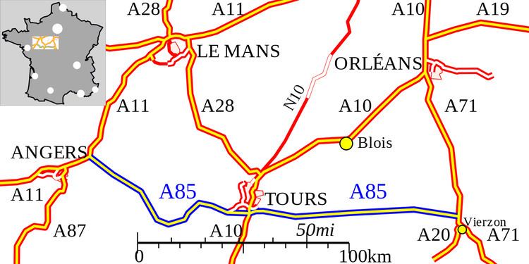
The A85 autoroute is a motorway in France. It connects the A11 at Angers to the A71 at Vierzon. It is 270 km long.

Contents

Map of A85, France

History

The motorway was opened in 1997. It starts at the Péage de Corzé north of Angers and in 1997 went to Bourgueil. In 2007 the Bourgueil to Langeais 26km extension was opened. In December 2007 the remaining Azay-le-Rideau to Theillay section opening making 206km in total.

Junctions

  • Exchange A11-A85 Junction with the A11 autoroute.
  • 01 (Beaufort-en-Vallée)
  • 02 (Longué-Jumelles)
  • 03 (Vivy-Saumur)
    Road site art: Le Cheval de Saumur
  • 04 (Brain-sur-Allonnes) (construction postponed)
  • 05 (Bourgueil)
  • 06 (Restigné) (construction postponed)
  • 07 (Langeais-Est)
  • 08 (Vallères-Villandry)
  • 09 (Druye-Tours)
  • Exchange A10-A85 Junction with the A10 autoroute.
  • 10 (Esvres)
  • 11 (Bléré)
  • 12 (Saint-Aignan)
  • 13 (Selles-sur-Cher)
  • 14 (Villefranche-sur-Cher-Romorantin-Lanthenay)
  • Exchange A71-A85 Junction with the A71 autoroute.
  • Proposed Extensions

  • Bourges to Chalon-sur-Saône via Nevers
  • Corzé to Rennes via Château-Gontier and Laval
  • Sections Now Open

  • Bourgueil to Langeais : Opened 29 January 2007(26 km)
  • Azay-le-Rideau to Esvres : Opening April 2008 (11lkm)
  • References

    A85 autoroute Wikipedia