
Existed: 2015 – present Constructed 2015 | Length 3.5 km | |
 | ||
History: First proposed during 1960s | ||
The A5758 road (also known as Broom's Cross Road or the Thornton Bypass) is a 2.2-mile (3.5 km) single-carriageway road, constructed during 2014–2015 and linking the A565 road in Thornton to Switch Island junction. The road is officially named the A5758 Broom's Cross Road, with Broom's Cross being the site of a medieval wayside cross near Thornton and the road numbering referencing the two motorways the road links to, the M57 and M58 motorway respectively.
Contents
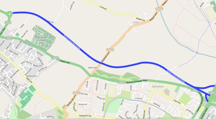
- Map of A5758 Liverpool L29 5XB UK
- Early proposals
- Public consultations
- Final decision
- Construction
- Route
- Operation
- References
Map of A5758, Liverpool L29 5XB, UK
Discussions about the need for the road to be constructed date back to the construction of Switch Island junction, with numerous public consultations held throughout the years to ascertain public support and opinion on the need for the road and the alignment it would take. The consultations have produced favourable responses from the majority of respondents, with several different alignment suggestions being proposed over the years.
Sefton Council gave their final approval in September 2013, with construction starting towards the end of the 2013 calendar year. The cost was in the region of £20.4m, with the UK Government contributing £14.5m towards that and Sefton Council contributing £5.9m. The financial benefits over the 60 years following construction of the road has been estimated to be in the region of £140–£200m.
Early proposals
The need for an improved route between Switch Island and the main Southport Road was first identified as far back as 1968, during planning for the M57, M58 and M62 motorways. Shortly after the motorways opened, a number of proposals to allow traffic to bypass Thornton and Netherton were developed, given increased road traffic over the years that followed added to the congestion throughout Thornton.
In 1990, a detailed proposal known as the Blue Route was submitted for planning permission, which would have involved a 4.7-mile (7.6 km) dual carriageway road between Switch Island and the Formby Bypass. This proposal was ultimately rejected by then Secretary of State for Transport in May 1995 despite favourable public consensus, on the grounds it would have negative impact on greenbelt land and be detrimental to conservation areas and protected species.
Public consultations
Five years later in May 2000, a public consultation began which proposed six possible options, with the intention to understand the views and opinions of residents and businesses along the route between Thornton and Switch Island. Following feedback, six options were considered for possible highway construction, those being:
Of all the considered options, Option 5 performed well during the appraisal process and was identified as being the preferred option to pursue by Sefton Council. A further consultation was undertaken in 2003, during which questionnaires were distributed to ascertain resident and business viewpoints on the proposal identified in the 2000 consultation; it determined nearly 80% of respondents agreed for the need of a new road as proposed, with the majority of those questioned strongly agreeing. Of those that did not agree to the preferred option, nearly a third (30%) expressed concerns that the proposal may result in increased congestion, whilst a quarter (25%) expressed a preference for the route to be constructed as a dual carriageway.
During a further consultation held 2006, local residents and businesses were sent another questionnaire asking them how strongly they agreed or disagreed with the proposed alignment and the need to restrict traffic levels and speeds once the proposed road had opened. Of the 12807 questionnaires that were sent, 10.9% were returned, with a further 100 completed at public exhibitions and online; the majority of responses were in agreement with the proposed alignment.
Final decision
Following the 2006 public consultation, the scheme for a single-carriageway link to Thornton was given high priority and accepted in July 2006 by the then-Secretary of State for Transport, Douglas Alexander. Funding was approved by the Department for Transport in February 2011 when Sefton Council accepted the terms and conditions that has been proposed. Following Sefton Council giving their final approval in September 2013, construction was proposed to take place throughout 2014-2015, with the financial benefits estimated to be in the region of £140m-£200m over the 60 years post construction.
Construction
Contractors Balfour Beatty marked out the route of the bypass in October 2013 offering the first glimpse of where the road would be built, following completion of the land acquisition after a public inquiry held in October 2012 raised two objections to the compulsory purchase order needed to acquire the land to build on.
Initial land works began in January 2014 with an initial expected date of completion being in the final quarter of 2014. As the initial completion period approached in November 2014, it was reported that the project had been delayed due to poor weather and ground conditions, with the completion date pushed back to Spring 2015. Despite this, construction works to connect the new road to the main junction at Switch Island concluded by the end of December 2014, with the second phase of works taking place mostly throughout the night in January 2015 to minimise disruption.
The road surface began to be laid in February 2015 with a revised opening of Spring 2015 forecast., yet reports in March 2015 confirmed that due to frost and rainfall, the date of opening had been postponed to at least May 2015.
Jospice, a local hospice close to the new road, organised a charitable walk along the new road prior to opening, with donations of £5 per person going towards the Jospice charity. The event occurred on Saturday 16 May 2015, after previously being postponed several times due to delays in construction.
After further slippage in the timescales, the opening date was revised from late June 2015 to 19 August 2015. The delay was explained as being due to needing to undertake additional work to stabilise the road foundation in two locations to make it suitable to lay tarmac on. The road opened on the evening of 19 August 2015.
Route
The route is constructed as a 10 metre wide, two lane single carriageway with 1-metre-wide (3.3 ft) hardstrips and a 2.5-metre-wide (8.2 ft) verge, with a 50-mile-per-hour (80 km/h) speed limit. The road has some sections on low embankment and others in shallow cutting where it runs close to existing residential properties, but is mostly close to existing ground level. Surface drainage is collected by a kerb and gully system and discharged into four new attenuation ponds. The route is only lit where there are specific safety reasons for doing so, such as junctions and crossings along the route. There are no footways along the route other than specific pedestrian crossing points.
The road starts at Switch Island junction, with direct connections to its namesake motorways (M57 and M58 respectively), as well as the A5036 and A59 roads which all converge at the junction. The road closely follows the route of the Northern Perimeter Road which is to its south, with the only major intersection being when it crosses the B5422 road. From there it continues in a North-West direction until it meets the A565 road, at a roundabout constructed as part of the scheme to improve efficiency for converging traffic.
Operation
It was reported in January 2016 that a section of the road would need to undergo a series of repair works during the evenings of a three-week period, just 5 months after opening to traffic. A year after opening, road users were giving generally positive feedback, with some confirming that travel times had been reduced and offers a more convenient means of accessing the motorways, although a common recurring concern were the junction issues at Switch Island.
Since opening, there have been reports relating to an increased number of road traffic incidents at Switch Island, the main terminus of the A5758 road. Some road users have noted that a lack of clear road markings and signage may be a contributing factor towards the traffic collisions, whilst Sefton Council noted that they continue to review the operation of the road and associated junctions. Following continued incidents at the junction with Switch Island, the council confirmed in July 2016 that it was in talks with Highways England and Merseyside Police with Bill Esterson, MP for Sefton Central, calling for changes to be considered to the road to improve safety.