
Formed November 8, 2013 Affected area Somalia | Dissipated November 11, 2013 | |
 | ||
Highest winds 3-minute sustained: 55 km/h (35 mph)
1-minute sustained: 85 km/h (50 mph) Lowest pressure 1002 hPa (mbar); 29.59 inHg Fatalities 162 confirmed, about 300 missing Areas affected Somalia (Puntland), Ethiopia Date 8 November 2013 – 11 November 2013 Similar Cyclone Onil, Cyclone Lehar, Cyclone Helen, Cyclone Viyaru, Cyclone Yemyin | ||
The 2013 Somalia cyclone, officially Deep Depression ARB 01, was the second deadliest tropical cyclone worldwide in 2013 as well as the deadliest to affect Somalia in its history. It formed as a depression in the Arabian Sea on November 8 and made landfall over Puntland as a deep depression on November 11. Although ARB 01 was a weak system, it still killed 162 people across the country while about 300 others were reported missing.
Contents
Meteorological history
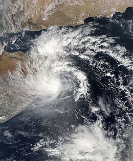
On November 6, 2013, the Joint Typhoon Warning Center (JTWC) began monitoring a broad low-pressure area over the southeastern Arabian Sea. Accompanied by bursts of convective activity, the low tracked generally westward over an area slightly favoring tropical cyclogenesis. Moderate wind shear offset the positive effects of upper-level outflow, though high sea surface temperatures aided further development. By November 8, organized banding features wrapped around the northwestern side of a consolidating circulation. Subsequently, the India Meteorological Department (IMD) classified the disturbance as Depression ARB 01 at 1000 UTC, making it the first tropical cyclone in the Arabian Sea during 2013. At this time, the depression was located about 680 km (425 mi) east-southeast of Ras Binnah, Somalia. Based on continued development, the JTWC issued a Tropical Cyclone Formation Alert two hours later before declaring the system as Tropical Cyclone 03A at 2100 UTC. A subtropical ridge to the north steered the system on a westward course that would bring it over Somalia in two days. Some limited intensification was anticipated, though it was also noted dissipation before landfall was possible.
Early on November 9, an Advanced Microwave Sounding Unit pass of the system revealed a mid-level eye feature, indicative of an intensifying system. However, shallow convection along with scatterometer data showed no strengthening. The IMD assessed the system to have become a deep depression around this time and attained its peak intensity, with three-minute sustained winds of 55 km/h (35 mph) and a barometric pressure of 1002 mbar (hPa; 29.59 inHg). The JTWC estimated the system to have been slightly stronger at its peak, with one-minute sustained winds of 75 km/h (45 mph). Continued moderate wind shear displaced most convection to the northwest of the center of circulation, counteracting the favorable poleward outflow which was enhanced by the mid-latitude westerlies. The wind shear took its toll by November 10, leaving the storm's center devoid of showers and thunderstorms. More pronounced decay took place later in the day as the storm neared the coastline, with land interaction disrupting the circulation. Between 2300 UTC on November 10 and 0000 UTC on November 11, the deep depression made landfall along the border of the Nugal and Bari regions. Based on estimates from the JTWC, the system became only the fifth known tropical storm to strike the country since 1966, when accurate satellite measurements were started. Retaining some organized convection, the system gradually weakened as it moved inland; it was last noted by the IMD later on November 11 as it neared Ethiopia.
Preparations and impact
On November 9, Puntland's Interior Minister Ali Yusuf Ali Hosh announced on Radio Garowe that the Puntland authorities had been informed by international meteorological agencies that flood-inducing cyclones were expected to hit Somalia's northeastern coast. The Puntland government concurrently firmed up on its surveillance system, alerting regional authorities, fishermen and other civilians of the impending tropical storm through the local media and via text messages.
The cyclone primarily impacted the Alula, Bayla, Dangorayo, Eyl and Hafun districts. Up to 350 mm (14 in) of rainfall was registered, around 100 mm (3.9 in) more than the average regional amount per year. According to the Puntland government, 140 fatalities were confirmed while an additional 300 people were listed as missing. Of 650 medical consultations, around 80 deaths were confirmed from hypothermia and exposure, mainly of children and the elderly.
According to the Puntland Disaster Management and Rescue committee, the torrential rains inundated littoral towns and faraway rural areas at a higher level than expected. A number of bridges, villages, buildings, homes and boats were destroyed during the storm. Photos taken by Puntland Maritime Police Force (PMPF) units using special boats captured images of submerged dirt roads between urban and rural areas, as well as debris from flattened houses and fallen trees that was blocking off parts of the Bosaso-Galkayo highway. Additionally, in part due to icy rain, around 100,000 livestock died. Regular flights to and from the Bender Qasim International Airport in Bosaso and the Abdullahi Yusuf International Airport in Galkayo were also affected by the cyclone's torrential rains, and the airports' gravel runways sustained some damage. Mobile phone masts were likewise destroyed, and electricity was interrupted.
Aftermath
The Puntland government established a Puntland Disaster Management and Rescue committee to oversee local relief efforts in the wake of the cylone. Puntland Maritime Police Force units and government rescue teams were also deployed to the impacted areas. PMPF troops assisted in the transportation of emergency supplies, including blankets, tents, non-perishable food items and medicines. Accessibility to the most affected areas was slowed by flash floods and the collapse of a bridge linking Bosaso with the administrative capital Garowe. Government rescue teams consequently utilized donkey carts to reach remote localities. The Puntland Highway Authority (PHA) also established an alternative land route for trucks transporting relief materials. In total, the Puntland government sent 32 trucks carrying supplies to the affected areas.
Along with the Puntland regional authorities, the Federal Government of Somalia declared a state of emergency in the cyclone struck areas. It also indicated that $1 million would be earmarked for the impacted communities. In addition, the Somaliland regional administration in northwestern Somalia pledged to provide humanitarian assistance. Neighboring Djibouti and Ethiopia also dispatched relief shipments.
According to OCHA, strong coordination between the Puntland government and humanitarian agencies led to an effective emergency response vis-a-vis the nearly 30,000 people affected by the cyclone. The UN World Food Programme sent 340 tons in food rations, intended to sustain around 4,000 impacted households for one month. The International Federation of the Red Cross likewise treated 757 individuals for acute respiratory infections and skin-related diseases over three days, and recommended that clean drinking water be made available to the impacted areas so as to avert waterborne illnesses like diarrhoea. In conjunction with the Somali authorities, the Qatar Alliance led by the Qatar Red Crescent also distributed essential supplies to around 1,000 impacted families.
By November 25, focus had shifted to rebuilding lost livelihoods, including the restocking of livestock. To this end, the Puntland government distributed around 15,887 heads of livestock in December to hundreds of pastoralist households affected by the storm. According to Puntland officials, the Bosaso and Galkayo airports' runways were also undergoing repair work.