
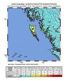
Origin time 8:04:08 p.m. (PDT) Magnitude 7.8 Mw Type Thrust Date 27 October 2012 | Duration 90 seconds Depth 17.5 km (10.9 mi) Areas affected Canada Location Canada | |
 | ||
Similar 1949 Queen Charlotte, 1925 Charlevoix–Kamouraska earthquake, 1946 Vancouver Island ear, 1663 Charlevoix earthquake, 1988 Saguenay earthquake | ||
The 2012 Haida Gwaii earthquake occurred just after 8:04 p.m. PDT on October 27. The shock had a moment magnitude of 7.8 and a maximum Mercalli Intensity of V (Moderate). The earthquake's epicentre was on Moresby Island of the Haida Gwaii archipelago (formerly known as the Queen Charlotte Islands). This was the second largest Canadian earthquake ever recorded by a seismometer, after the 1949 Queen Charlotte Islands earthquake, about 135 kilometres (84 mi) away.
Contents
Earthquake
Strong shaking was felt throughout Haida Gwaii where residents in Masset, Skidegate, Sandspit, and Queen Charlotte City were evacuated to higher ground. Minor shaking was felt in Prince Rupert and in other cities of the Interior such as Prince George, Quesnel, and as far away as Kamloops. Electricity service was interrupted in Bella Coola.
Although the earthquake occurred on the Queen Charlotte Fault, a primarily strike-slip boundary between the Pacific and North American plates where the Pacific Plate moves approximately north-northwest with respect to the North America plate at a rate of about 50 mm/yr., the 2012 quake exhibited a thrust mechanism, more characteristic of the Cascadia Subduction Zone to the south.
Tsunami
A tsunami warning was issued for the North American Coast from the Alaskan Panhandle to Vancouver Island, but later limited to the North Coast region of British Columbia. Canadian authorities were questioned for issuing a tsunami warning nearly 40 minutes after the U.S. had issued their warning. The greatest wave heights recorded at tide gauges in Canada were 0.25m (9.8 in.) at Langara Island and 0.22m (8.7 in.) at Winter Harbour. In Tofino on Vancouver Island, the tsunami warning sirens were activated and residents in low-lying areas evacuated their homes. The maximum wave height recorded in Tofino was 0.09m (3.5 in.). Tofino's tsunami warning system was activated after communication with the provincial coordinating centre was cut off.
In the U.S., Hawaii was also placed on alert, and over 100,000 people were evacuated to higher ground. The maximum wave height recorded at tide gauges in Hawaii was 0.79m (31 in). Other warnings were issued for the states of Oregon and California, but were subsequently lifted.
Damage
Despite the earthquake's large magnitude, no major structural damage was reported from any of the population centres in the vicinity. This can be explained by the remoteness of the tremor's epicentre. No casualties or major injuries were recorded from the quake, likely due to the sparsely populated nature of the region. As a result of the earthquake and its aftershocks, the famed hot springs in Gwaii Haanas National Park on Hotspring Island dried up.
Aftershocks
There were 94 aftershocks of magnitude 4.0 or greater lasting until November 7, as recorded by the USGS.
The largest of these numerous aftershocks was a 6.3 magnitude earthquake that occurred 56 kilometres (35 mi) to the west of the main tremor on the morning of October 28. This was followed on October 29 by a 6.2 aftershock 50 kilometres (31 mi) to the south of the original quake.