
Formed October 28, 2006 Damage unknown Dissipated 4 November 2006 | Lowest pressure 988 mb (29.18 inHg) Highest winds 100 km/h | |
 | ||
Areas affected Central North Pacific Ocean to British Columbia | ||
2006 central pacific cyclone top 5 facts
The 2006 Central Pacific cyclone, also known as 91C.INVEST or Storm 91C, was an unusual weather event of 2006. Forming on October 30, from a mid-latitude cyclone in the north Pacific mid-latitudes, it moved over waters warmer than normal. The system acquired some features more typical of subtropical or even tropical cyclones. However, as it neared western North America it fell apart. Moisture from its remains then caused substantial rainfall in British Columbia. The exact status and nature of this weather event is unknown, with meteorologists and weather agencies having differing opinions.
Contents
- 2006 central pacific cyclone top 5 facts
- Meteorological history
- Impact preparation and records
- Nature of the system
- References
Meteorological history
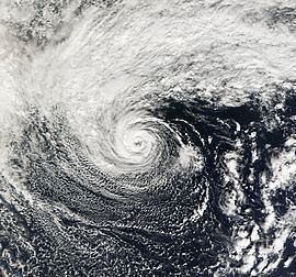
A cut-off extratropical cyclone over the central north Pacific moved over an area of ocean with sea surface temperatures as high as 2 °C above normal for two days. By October 31 the system had acquired convection, a warmer-than-normal core, and an eye-like feature. During this time it had moved east, then northeast, and then northwest. On November 1, the system had estimated winds of 100 km/h (60 mph) and its most developed convection. After that, it slowly weakened, looped counter-clockwise, and headed east towards the west coast of North America. On November 2, wind shear started taking its toll, and all convection was gone by the next day, when it was located roughly 520 mi (840 km) off the coast of Oregon. This system's center of circulation passed south of observation buoy 46637 on November 1. The buoy's lowest pressure reading was 989 mb/hPa. Other buoys indicated that a rather large area of low pressure was associated with the system. Buoy 46637 was not at the system's center of circulation, so it is possible that this system had a lower minimum pressure than was actually measured.
Impact, preparation, and records
In response to the weather system, the American National Weather Service issued wind watches for the Oregon Coast. The system brought heavy rain to portions of Vancouver Island.
If Storm 91C is considered a tropical or subtropical cyclone, it holds several records. Since the storm is not official, its holding of these records is also unofficial. Since it formed at 36°N, this system is the northernmost formation in the eastern north Pacific basin. The previous record-holder was Tropical Storm Wene, which formed at 32°N before crossing the dateline. In addition, this system's track data indicates that it crossed from the central to the east Pacific because it formed at longitude 149°W and dissipated at 135°W. Only two recorded other tropical cyclones had done that previously.
Nature of the system
This system has been considered a tropical, subtropical, or extratropical cyclone.
Mark Guishard, a meteorologist with Bermuda Weather Service, was of the opinion that the system had completed tropical cyclogenesis and was a tropical cyclone. Meteorologist Mark Lander thought that cloud tops were similar to several Atlantic hurricanes, Hurricane Vince in particular. James Franklin, a meteorologist at the National Hurricane Center, said:
The system was of frontal origin... the frontal structure was eventually lost.... The convective structure resembled a tropical, rather than subtropical cyclone, and the radius of maximum winds (based on QuikSCAT) was very close to the center, also more typical of tropical cyclones... on balance, it was more tropical than subtropical.
Clark Evans of Florida State University reported that forecasting tools showed that the system's structure was consistent with that of a subtropical or marginally tropical cyclone. NASA, which is not a meteorological agency, thought that the system was a subtropical cyclone.
In its review of the 2006 Atlantic hurricane season, the Canadian Hurricane Centre considered this to be an extratropical cyclone.
Since this system had one-minute sustained winds of 100 km/h (60 mi/h), which are above the 60 km/h (39 mi/h) boundary between a depression and a storm, it would qualify as a named storm if it was a tropical or subtropical cyclone. However, neither of the official Regional Specialized Meteorological Centers for the eastern north Pacific, the National Hurricane Center and the Central Pacific Hurricane Center, include this system in their annual archives, nor is it included in the official "best track" file. Hence, this system is not an official tropical or subtropical cyclone of the 2006 Pacific hurricane season.