
 | ||
The 1998 Eastern Tornado Outbreak of June 2, 1998, was one of the most significant tornado outbreaks in recent history over the east-central United States. This severe weather event spawned a total of 47 tornadoes over 9 states from New York to South Carolina and caused an estimated $42 million in damage, 80 injuries and 2 fatalities. For Pennsylvania in particular, it was the second historic and deadly severe weather outbreak in three days, as it immediately followed the Late-May 1998 Tornado Outbreak and Derecho on May 30–31, 1998, which spawned 41 tornadoes over New York, New Jersey, Pennsylvania and Vermont, caused an estimated $83 million in damage, 109 injuries and 1 fatality.
Contents
- Meteorological synopsis
- Tornado summary by state for June 2 1998 and early June 3 1998
- Pennsylvania
- Beaver Allegheny and Westmoreland Counties
- Fayette and Somerset County F2 and F3 tornadoes
- Wyoming County F3 Tornado 2 Deaths 15 Injuries
- Pennsylvania tornado summary
- West Virginia
- Charleston West Virginia tornado and severe thunderstorm
- Glade Farms tornado northeast Preston County
- Mineral and Hampshire County tornadoes
- West Virginia tornado summary
- Maryland
- Allegany County tornadoes and the F4 Frostburg tornado
- F2 Friendsville tornado Garrett County
- Western Maryland tornado summary
- New York
- Tennessee
- Virginia
- North Carolina Ohio and South Carolina
- Other states affected by severe weather
- References
Hardest hit areas from the June 2 tornado outbreak included Pennsylvania, which reported 22 tornadoes on June 2 (and a total of 45 tornadoes from May 31 to June 2), western Maryland, where 5 tornadoes occurred, and West Virginia, where some counties in the Potomac Highlands reported their first tornado in recent history. Tornadoes were also observed in New York, Virginia, Ohio, Tennessee, North Carolina and South Carolina. The most damaging tornado hit Carnegie, part of the Pittsburgh metropolitan area in Allegheny County, Pennsylvania, at 5:55 PM EDT. There, 50 injuries and $13 million in damage were reported. The deadliest tornado, an F3 on the Fujita Scale, hit near Meshoppen, Pennsylvania, in Wyoming County, around 10:30 PM EDT. This tornado caused 2 fatalities, 15 injuries and $2.2 million in damage. The most violent tornado hit Frostburg, Maryland, in Allegany County, at 9:43 PM EDT. 5 persons were injured, and $5 million in property damage was reported. With winds up to 210 mph, it was the first F4 tornado to have hit the state of Maryland since the National Weather Service began keeping records in 1950. The Frostburg Tornado had moved southeast from Somerset County, Pennsylvania, where it was rated F3.
The 1998 Eastern Tornado Outbreak stands out, because it spawned an unusually high number of supercell thunderstorms, occurrences of damaging winds and hail, and tornadoes, in the central Appalachian Mountain area, where most residents were unaccustomed to experiencing such violent thunderstorms that are commonly believed to only occur in Tornado Alley in the central part of the United States.
Meteorological synopsis
June 2, 1998, began with very stable atmospheric conditions in the areas later affected by severe weather. Fair skies and near-record low temperatures were noted in the east-central U.S., with minimum temperatures reaching the 40s in many areas, and upper 30s in portions of northern Pennsylvania and New York State. Dew points were in the 30s and 40s. However, a potent upstream disturbance approaching the region quickly destabilized the atmosphere, placing the region in a moderate risk for severe weather. A moderate risk is unusual for this portion of the U.S. Significant surface heating (temperatures quickly reached the 80s and even 90s in some areas), a significant influx of moisture (pushing dewpoints well into the 60s in many areas), a rapid increase in atmospheric shear, steep adiabatic lapse rates, rapidly lowering lifted indices, and a major surge in CAPE set the stage for a major severe weather outbreak during the afternoon and evening hours of June 2.
Skew-T log-P diagram plot of atmospheric profile at 00z, June 3, 1998, at IAD (Dulles Airport). Courtesy of the National Weather Service (NWS) Sterling, Virginia.
The above atmospheric profile indicates several unusually favorable factors for development of severe weather, including tornadoes. One is these is significant vertical wind shear. The wind barbs on the right indicate significant speed and directional shear with height in the lower 500 mb of the atmosphere. Winds veer significantly, from SW at the surface to NW at 500 mb, and also increase from 8 kts at the surface to 46 kts at 500 mb, leading to a vertical shear value of 44 s −1. This exceeds the "high potential" severe weather threshold of 40 s −1. Veering winds with height indicate warm air advection; this, coupled with strong surface heating, contribute significantly to destabilization of the atmosphere. The second favorable feature on the plot is the steep vertical temperature gradient in the lower atmosphere up to the Lifted condensation level (LCL) - from 26.4 C at the surface (989 mb) to about −5 C at the LCL, which is about 600 mb. While the 600 mb height is unknown, it is likely that the atmospheric lapse rate is close to or exceeds the threshold for absolute instability, strongly driving convection. Air is therefore forced to rise rapidly, leading to a significant latent heat release (LHR), providing further energy for severe thunderstorms. Other strongly favorable conditions for severe weather are a highly negative (-6.1) lifted index (which exceeds the threshold of −6 for "high potential" of severe weather) and a CAPE value that peaked at 3.8 kJ, well over the threshold of 2.5 kJ for a high potential of severe weather. Vertical velocity at the surface is 13.6 m s −1, indicating strong rising motion.
Severe supercell thunderstorms developed rapidly during the afternoon and evening hours. The first tornadic supercell developed over southeastern Ohio and spawned the first tornado at 2:50 EDT near Gallipolis, where many trees were downed and large hail accumulated. This supercell crossed the Ohio River into West Virginia, where tornado damage continued. The second tornadic supercell dropped its first tornado in extreme western Pennsylvania near Shippingport. This storm later caused major damage and 50 injuries in the Pittsburgh metro area before moving southeast through Somerset County, where many residents were still without power after the deadly May 31 Salisbury tornado. The majority of the June 2 tornadoes formed between 5:30 pm and 11 pm EDT. All of Pennsylvania's 22 tornadoes occurred between 5:30 and 10:40 local time, 14 of them from 7 to 10 pm.
Tornado summary by state for June 2, 1998, and early June 3, 1998
Pennsylvania
West Virginia
Maryland
New York
Tennessee
Virginia
North Carolina
Ohio
South Carolina
Eastern United States
Pennsylvania
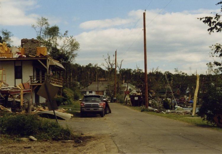
Pennsylvania was by far hardest hit by the 1998 Eastern Tornado Outbreak. The state experienced an unprecedented 45 tornadoes in a three-day period between May 31 and June 2, 1998, along with hundreds of total severe weather reports. Many residents were still cleaning up from the violent May 31 storms when the June 2 severe storms struck. 22 tornadoes touched down in the state. Both deaths from the June 2 outbreak, and all three total deaths from the May 31 and June 2 outbreaks, occurred in Pennsylvania. Of the 80 injuries, 66 also occurred in Pennsylvania.
Beaver, Allegheny and Westmoreland Counties
The first tornado in Pennsylvania developed in the town of Shippingport in Beaver County, where significant structural damage occurred. The supercell moved southeast into the Pittsburgh Metro Area, where $13 million in structural damage and 50 injuries were reported. The tornado was first sighted 5 miles northwest of Carnegie and tracked 2 miles southeast of downtown Pittsburgh before tracking from Allegheny County into Westmoreland County. There, major tornado damage was reported in and around the towns of Irwin and Donegal, where the twister overturned a mobile home and a tractor trailer along the PA Turnpike, injuring the driver. The Carnegie-to-Irwin twister was on the ground for at least 26 miles. It was the first tornado to hit Pittsburgh since 1944.
Another supercell thunderstorm developed over extreme eastern Ohio and spawned tornadoes and other severe weather (damaging winds and hail) over virtually the same areas that were hit only two hours prior. Tornadoes touched down yet again near Shippingport and Irwin. Because of the nearly identical tracks of the supercells, very heavy rain fell over a narrow northwest-to-southeast swath, prompting flash flood warnings over Allegheny and Westmoreland Counties. A SKYWARN spotter reported an inch of rain in only 12 minutes, and Mt. Pleasant recorded 2.07" of total rainfall.
Fayette and Somerset County F2 and F3 tornadoes
Two major tornadoes passed through already hard-hit Somerset County, Pennsylvania, within about two hours of each other, and taking almost identical tracks. An F2 tornado touched down near Markleton at 7pm EDT, crossed the path of the Salisbury tornado 6 miles east of Salisbury (where a fatality occurred from the F3 tornado two evenings prior), hit Boynton and ended in Pocahontas, tracking a total of 15 miles in the county. Damage was mainly limited to forested areas, and no deaths or injuries were reported.
The second, and stronger, tornado touched down in extreme eastern Fayette Co., about 4 miles southeast of Indian Head. The tornado rapidly intensified to F3 status near Bakersville in Somerset County, and maintained F2 to F3 intensity as it tracked southeast, virtually parallelling the path of the F2 tornado that struck the county just two hours prior. Many farms were demolished, and while no major injuries were reported, hundreds of livestock, some of which were thrown miles through the air, were killed. Residents of Boynton were cleaning up debris from the evening's first tornado when firefighters warned residents to seek shelter again, because another tornado was on its way. Near Pocahontas, Amish farmers had already rebuilt the framing of a carpentry shot destroyed by the May 31 tornado when this third tornado quickly leveled the building again. This storm also crossed the path of the May 31 Salisbury tornado, 3 miles east of town, and continued through extreme northeastern Garrett and Allegany County, Maryland, where it intensified to a violent multi-vortex F4 tornado in and around Frostburg (see more details in the Maryland section). This tornado tracked for an amazing 48 miles, with a path width up to 1 mile in Somerset County, Pennsylvania, before finally dissipating 2 miles north of Cresaptown, Maryland.
Shortly prior to the F4 tornado striking Frostburg, Maryland, another F2 tornado formed in southern Fayette County, Pennsylvania, just southwest of the town of Elliotsville. The tornado first touched down at 9:35 pm and tracked 12 miles through Fayette County, Pennsylvania; Preston County, West Virginia; and Garrett County, Maryland. The same supercell also spawned destructive tornadoes in Mineral and Hampshire Counties in the eastern panhandle of West Virginia. Major property damage occurred in southeastern Fayette County. A dairy barn and two mobile homes were completely destroyed. Twenty-one other structures were heavily damaged. Herds of cattle were killed, including one that was thrown through the air over 100 yards. Approximately $3 million in structural damage and $2 million in timber and crop damage was reported in Fayette County alone. See below for details on this F2 tornado as it subsequently tracked southeast through Preston County, West Virginia, and into Garrett County, Maryland.
The same areas ravaged by severe weather on May 31 and June 2, 1998, would be slammed once again by violent thunderstorms exactly two weeks later on June 16 and yet again exactly two weeks after that, on June 30. On June 16, another tornado, an F0, hit rural Westmoreland County, and an F1 twister struck Johnstown in Cambria County. Two F1 tornadoes were also confirmed in Lycoming County On June 30, yet another tornado, an F1, touched down in Somerset County, and an F0 tornado hit Cambria County. Both events were associated with numerous large hail and hundreds of damaging wind reports.
Wyoming County - F3 Tornado - 2 Deaths, 15 Injuries
Perhaps the most significant, and the only fatal, tornado from the June 2 outbreak occurred in north-central Wyoming County, Pennsylvania. A supercell thunderstorm rapidly intensified over Bradford County, first spawning a tornado in Terry Township between 10:15 and 10:20 pm, in the southeastern part of the county. Several buildings were heavily damaged as the tornado reached F1 intensity.
The tornado lifted briefly, before touching down again in northern Wyoming County, on the east side of Valentine Hill, and generally moved east-southeast. The twister intensified as it continued across the northern portion of Stevens Lake, over a hill and towards Lake Carey. A narrow strip of land and road (State Route 1003), which formed a causeway across Lake Carey, was in the path of the twister. This is where complete destruction and death occurred around 10:30 pm. Every building on this narrow strip of land crossing the lake was virtually leveled. Two people, an elderly woman and her grandson, were ejected from their home and thrown into an adjacent house, killing both of them upon impact. Every tree in the path of the tornado was uprooted, snapped, or leveled in a chaotic pattern. Docks along the eastern shore of the lake were destroyed, and many boats were tossed inland. As the tornado continued east-southeast, massive damage continued, with more leveled homes and a swath of tree destruction averaging 500 yards wide. In addition to the 2 deaths, the tornado caused 15 further injuries. 42 homes in the Lake Carey vicinity were heavily damaged or destroyed, with dozens more buildings severely damaged in the tornado's path, which exceeded 1⁄3 of a mile in some areas and was 35 miles long.
The tornado continued 3 miles into northern Lackawanna County, weakening to an F1 and finally lifted just west of Abington Road. Portions of the Keystone College sustained significant tree damage and damage to classroom buildings. Windows were blown out, and gutters were twisted. The tornado crossed routes 6 and 11 and caused major tree damage in the Pinchot State Forest. The total structural damage from this tornado was estimated at $2.2 million.
Pennsylvania tornado summary
Many other areas of Pennsylvania were severely affected by tornadoes on June 2, 1998. Below is a table summarizing the 22 tornadoes that occurred. There were also 27 reports of severe wind damage and 66 reports of severe hail in the state. Hail up to 2 inches in diameter was reported in Lawrence County at Bessemer and just southwest of New Castle, and also in extreme northeastern Fayette County at Seven Springs Resort / Champion, all around 6:40 pm EDT.
West Virginia
The June 2, 1998, severe weather outbreak also heavily affected portions of West Virginia, particularly the northern and eastern sections. West Virginia experienced 9 tornadoes, along with 4 severe wind damage reports and 14 reports of severe hail. While most of the severe storms passed through northern West Virginia and its eastern panhandle, the worst monetary damage occurred from an isolated but very intense supercell that tracked southeastward across the southern portion of the state all the way from the Ohio River to the Virginia border.
Charleston, West Virginia, tornado and severe thunderstorm
A severe, rotating supercell thunderstorm formed in southeastern Ohio, near the town of Gallipolis. This was the first supercell to spawn a tornado during the June 2 severe weather episode. Tornadoes touched down multiple times on the storm's southeastward track through three states, and the supercell produced large, destructive hail and damaging winds virtually everywhere in its path. The tornado first touched down near Gallipolis at 2:50 pm EDT, then the storm crossed the Ohio River into Mason County. F1 tornado damage was reported 5 miles southeast of Apple Grove at 3:15 pm. A man was injured when a tree fell on his van during the twister. The F1 tornado continued into Putnam County, uprooting or snapping hundreds of trees just west of Pliny at 3:16 PM. The supercell tracked southeastward along the Kanawha River Valley and made a direct hit on the state's capital city of Charleston. Most of the storm's damage resulted from large hail, up to 2 inches in diameter, which demolished vehicles and damaged sidings and windows of many buildings. $8 million in hail damage was reported, along with $3 million in wind damage and $1,000 in tornado damage in the Charleston area, over $11 million in total damage. The hardest hit area of the city was the Kanawha City area. The tornado moved up Chappell Hollow in Kanawha City at 3:58 pm, knocking trees onto homes, while hail up to 2 inches in diameter and widespread wind damage ravaged the area. A fourth tornado touched down just southwest of Leewood in Kanawha County at 4:19 PM. While the monetary damage was tremendous, no injuries or fatalities occurred. The supercell continued through Fayette, Raleigh, Summers and Monroe counties, primarily producing large hail. The hail reached 2.25" in diameter in Red Sulphur Springs in Monroe County at 5:15 PM. The supercell thunderstorm continued producing significant damage into southwestern Virginia.
Glade Farms tornado, northeast Preston County
The same tornadic supercell that began in southern Fayette County, Pennsylvaniua, tracked southeastward and clipped the northeast section of Preston County, causing extensive property and crop damage in the Glade Farms area, near Bruceton Mills at 9:45 pm EDT. $5 million in property damage was reported in Preston County, with an additional $2 million in crop damage, as the F2 tornado passed over numerous farms, killing livestock and damaging or destroying virtually everything in its path. A clearly visible 300-yard wide, 1-mile long swath of trees which were completely sheared or uprooted was present near the Pennsylvania/West Virginia state border. Despite the heavy damage, no injuries occurred from this strong tornado. The tornado continued its southeastward track into Garrett County, Maryland, as an F2.
Mineral and Hampshire County tornadoes
Two of the severe supercells that produced tornadoes in southwestern Pennsylvania and western Maryland continued into portions of Mineral and Hampshire Counties in Potomac Highlands of West Virginia. The first storm, which had produced multiple tornadoes in Somerset County, Pennsylvania, and Allegany County, Maryland, dropped another tornado, along with large (1.75" diameter) hail and damaging winds, as it passed through the northeastern tip of Mineral County near Wagoner at 8:36 pm, and crossed into northern Hampshire County. This was the first tornado in recent history to touch down in Hampshire County. There, the F1 tornado caused significant damage just north of Donaldson, including a destroyed gazebo, damaged siding to homes, and severe tree damage. The tornado passed over River Mountain and continued across the South Branch Potomac River, before dissipating near Levels at 8:46 pm.
The second tornado, also an F2, was associated by the same supercell that had ravaged Fayette County, Pennsylvania; Preston County, West Virginia; and Garrett County, Maryland. While the tornado lifted over eastern Garrett County, numerous funnel clouds were sighted over Bloomington in Garrett County, and one of the funnel clouds touched down on the east side of Green Mountain (along the Alleghany Front) in Mineral County, 5 miles southwest of Keyser, at 10:33 pm EDT. A car was blown over and many trees were uprooted, some thrown onto houses. The twister crossed New Creek Mountain before destroying a mobile home, crossing US Route 220, and causing major damage to forested areas and more structural damage. Another mobile home was rolled near Ridgeville near U.S. Route 50, and a barn was destroyed near Mill Creek Country Club, just west of Burlington.
The tornado rose up and over Patterson Creek Mountain, crossing into Hampshire County again at 10:47 pm EDT. Several mobile homes were severely damaged, some rolled Davy Road. Five persons in one of the overturned mobile homes were injured. A station wagon was completely turned around. The twister finally dissipated 3 miles south of Junction at 10:51 pm. Large hail from the supercell caused significant damage to trees and crops, and completely destroyed one farmer's orchard of fruit trees.
The two tornadoes that hit Mineral and Hampshire Counties were unprecedented in recent history and caught many area residents, who believed supercell thunderstorms and tornadoes only occurred in the Midwest and the Great Planes, completely by surprise. As with the Frostburg Tornado, however, swift actions by area residents and prompt NWS warnings likely saved many lives.
West Virginia tornado summary
Below is a table summarizing the 9 tornadoes that occurred throughout the state of West Virginia on June 2, 1998.
Maryland
The state of Maryland was also hit hard by the June 2, 1998, severe weather and tornado outbreak. There were 5 tornadoes in the two westernmost counties (Garrett and Allegany), including the strongest Maryland tornado to date, an F4 in the town of Frostburg in extreme western Allegany County. There were also 6 reports of damaging winds, and 21 reports of severe hail throughout the state. Golf ball sized (1.75" diameter) hail and larger was common in many areas, with the largest hail of 2.25" in diameter in the Laytonsville area of Montgomery County and 2.00" in diameter in Crofton, Anne Arundel County. Unofficially, hail reached 2.50" in diameter at some locations. Hardest hit areas from large, damaging hail were in central Maryland and included northern Montgomery, Howard, southern Carroll, southern Baltimore, and northern Prince George's and Anne Arundel Counties, between 7 and 8:45 pm.
Allegany County tornadoes and the F4 Frostburg tornado
Three severe supercell thunderstorms that tracked southeast from the Pittsburgh, Pennsylvania, area and through Somerset County, Pennsylvania, tracked through northwest and central Allegany County, Maryland, all taking an almost identical track to one another. A total of 3 tornadoes were spawned from two of the cells, the final cell producing Maryland's strongest tornado to date (a deadly, high-end F4 tornado hit La Plata in 2002), ironically in the statistically least likely county in the state to experience tornadoes.
The first tornado, an F1, hit the Mt. Savage Junction area just north of Frostburg at 7:56 pm EDT. The tornado lifted as it passed over Frostburg and nearby areas. Funnel clouds were sighted over Frostburg, La Vale, Haystack Mountain, South Cumberland and Mexico Farms. The second tornado touched down on Irons Mountain, 3 miles southeast of Cumberland, at 8:21 pm. Damage from both tornadoes were limited to forested areas and did not cause any injuries. However, large hail (0.75" to 1.0") fell in Mount Savage, La Vale, Cumberland and Oldtown, where property and crop damage was reported. The storm continued producing damage, including F1 tornadoes, as it tracked southeast into Mineral and Hampshire Counties in northeastern West Virginia.
A second severe thunderstorm within the hour tracked slightly northeast of the first severe cell, producing penny-sized hail in Flintstone (which had been hit hard with damaging winds two evenings prior from the same supercell that had produced a deadly F3 tornado in Salisbury, Pennsylvania) at 8:53pm.
The third supercell in less than 2 hours took a virtually identical track to the first tornadic storm. The storm, which first produced a tornado in eastern Fayette County, Pennsylvania, tracked southeast through Somerset County, Pennsylvania, the tornado wavering between F2 and F3 intensity, clipped the northeast corner of Garrett County, producing F2 damage in Finzel at 9:38 pm EDT. Several buildings were destroyed in the twister's path, though no one was injured. The tornado roared down Big Savage Mountain, intensifying to a violent, multi-vortex F4 as it demolished the northwestern, northern and eastern sections of Frostburg, beginning at 9:43 pm. The tornado tore a massive swath of destruction in Zihlman, Eckhart Mines and Clarysville, where it crossed US Route 40 (Alternate) and I-68, and continued up Dans Mountain. The tornado finally lifted on the east side of Dan's mountain 2 miles north of Creasaptown, after having been on the ground for an amazing 48 miles.
Twenty-nine homes in the tornado's path were destroyed, and another 125 were heavily damaged. Homes along Armstrong Avenue were hardest hit, as they were in the direct path of the twister. Roofs were blown off, and some houses were stripped down to their bare foundations. One family who rode out the storm in their basement looked up after the twister passed and were amazed to see stars - the entire house was obliterated. Frost Elementary School also sustained significant damage. Dozens of cars were damaged, many totaled. Some vehicles and other large objects were tossed large distances through the air. Every tree in the tornado's path was destroyed. Property damage was estimated at $5.0 million. Winds were estimated at 210 mph, the strongest tornado to date in Maryland history and the first ever F4. Prompt NWS warnings, tornado sirens and appropriate actions by area residents limited casualties. In fact, no fatalities were reported, and only 5 people received minor injuries.
The Frostburg Tornado was so powerful that debris from Frostburg, including a high school diploma, personal checks and a bill that had been in a basement file cabinet, was found nearly 100 miles downstream, near Sterling, Virginia. According to Vortex Times, The Frostburg Tornado was the fifth most intense tornado in the entire United States in 1998.
The 1998 F4 tornado was not the first twister to hit Frostburg. The city and nearby areas were also struck by an F2 tornado on November 23, 1891, an F1 tornado on June 23, 1944, and another F2 tornado on July 5, 1969.
Images of the 1998 Frostburg Tornado's damage can be found here:
Frostburg Tornado damage - from the NWS Sterling, Virginia
Another severe supercell clipped the extreme southwest portion of Allegany County about a little less than an hour later. See below for details on this severe thunderstorm, which spawned significant tornadoes in Fayette (PA), Preston (WV), Garrett (MD), Mineral (WV) and Hampshire (WV) Counties to the south and west.
F2 Friendsville tornado, Garrett County
Around the same time of the Frostburg Tornado, a separate supercell, spawning an F2 tornado, passed through southern Fayette County, Pennsylvania, the northeastern corner of Preston County, West Virginia, then tracked southeast into Garrett County, Maryland. A 300-yard wide swath of total tree destruction was seen as the tornado crossed I-68 in Maryland, just west of Friendsville, near mile marker 1. Between 9:50 and 10:00 pm EDT, several residences near and just SW of Friendsville were heavily damaged or destroyed by the twister, with property damage estimated at $1.0 million. No fatalities or injuries were reported. The tornado was on the ground for at least 3 miles. The damage was consistent with F2 intensity. While the tornado lifted as the parent supercell tracked over eastern Garrett County, numerous funnel clouds were sighted in the Bloomington area, and the storm produced another F2 tornado that ravaged portions of Mineral and Hampshire Counties in eastern West Virginia (see below for more details).
Western Maryland tornado summary
Below is a table summarizing the tornadoes that hit Garrett and Allegany Counties in western Maryland on the evening of June 2, 1998.
New York
Three (3) confirmed tornadoes touched down in central and western New York State on the evening of June 2, 1998. Two of the tornadoes were rated F1 and one was rated F2 on the Fujita scale. The two F1 twisters in central New York were spawned by the same supercell thunderstorm and touched down in eastern Cortland County in Cincinnatus and northwestern Chenango County in Pitcher, shortly prior to 8:00 pm EDT. Most damage was confined to wooded areas, although in Cincinnatus, a roof was blown off a house.
In Wyoming County, a multi-vortex F2 tornado struck Wyoming County, beginning in Orangeville, passing through Perry and continuing through Castile. While this is a relatively rural area, many structures were damaged or destroyed. In Orangeville, two barns and a modular home were leveled, and four aircraft - three airplanes and a helicopter - were damaged and the hangar completely destroyed. More barns and homes were damaged or leveled just south of Warsaw. In Perry, 13 mobile homes and several larger buildings were heavily damaged. In Castile, several buildings within a fertilizer plant were leveled. The tornado's path was 15 miles long. Many trees and wires were damaged or destroyed. However, no injuries or fatalities occurred.
Tennessee
Three (3) confirmed tornadoes touched down in Tennessee. One was rated F0 and two were rated F1. One F1 tornado touched down just southeast of Smyrna in Rutherford County, in central Tennessee, the afternoon of June 2. Two large buildings were destroyed, including Grand Slam USA, an indoor sports facility, and a wall was blown out of another business.
On the morning of June 3, an F0 twister developed over northeastern Carter County in extreme eastern Tennessee, causing structural damage to several homes, an entire farm and a church in the Holly Springs and Stony Creek areas. While the twister was on the ground intermittently, it intensified to an F1 as it moved into southwestern Johnson County, where major structural damage and three injuries were reported. Near Pandora, the tornado destroyed a home, with mattresses from the house thrown a mile through the air and family photos found 2 miles away. A three-horse trailer was thrown a quarter mile over a hilltop.
Virginia
Two (2) confirmed tornadoes touched down in northern Virginia around 10:00 pm on June 2, 1998, both rated F0 and emanating from the same storm cell. In Clarke County, a barn's roof was blown off and several trees were uprooted. Tree damage indicated a second tornado touchdown in western Loudon County on local route 734. No injuries were reported.
North Carolina, Ohio and South Carolina
One (1) confirmed tornado touched down in each of these 3 states, all three rated F0. The same supercell that later produced tornadoes and large hail in the Charleston, West Virginia, area developed in Jackson County in southern Ohio on the afternoon of June 2. The storm intensified and spawned a tornado in Gallia County. The twister damaged many large trees around Rio Grande and Gallipolis, and large hail accumulated in the streets of Gallipolis, denting and breaking the windows of numerous vehicles.
An F0 tornado just west of Zionville in western part of Watauga County in northwestern North Carolina destroyed multiple barns and toppled trees and power lines. In central South Carolina, an F0 twister downed a well-defined path of trees on state highway 432, about 5 miles southeast of Saluda, in Saluda County.
Other states affected by severe weather
Portions of Washington, D.C., Delaware, New Jersey and eastern Kentucky reported significant damage due to straight-line winds, often in excess of 58 mph, and especially large hail, ranging from the size of nickels (about 0.75 inch in diameter) to baseballs (about 2.75 inch in diameter) from this historic severe weather event. These severe weather phenomena were also common in all 9 states affected by tornadoes, particularly in thunderstorms that spawned funnel clouds and tornadoes. In addition, localized damage due to lightning and/or flash flooding was common over much of the affected region.