
Formed August 30, 1932 Fatalities 16 direct | Dissipated September 17, 1932 Highest winds 257 km/h | |
 | ||
Lowest pressure ≤ 921 mbar (hPa); 27.2 inHg Date 30 August 1932 – 13 September 1932 Similar 1933 Tampico hurricane, 1933 Cuba–Brownsville hurricane, Hurricane Carol, 1924 Cuba hurricane, 1932 Cuba hurricane | ||
The 1932 Bahamas hurricane, also known as the Great Abaco hurricane of 1932, was a large and powerful Category 5 hurricane that struck the Bahamas at peak intensity. The fourth tropical storm and third hurricane in the 1932 Atlantic hurricane season, it was also one of two Category 5 hurricanes in the Atlantic Ocean that year, the other being the 1932 Cuba hurricane. The 1932 Bahamas hurricane originated north of the Virgin Islands, became a strong hurricane, and passed over the northern Bahamas before recurving. The storm never made landfall on the continental United States, but its effects were felt in the northeast part of the country and in the Bahamas, especially on the Abaco Islands, where damage was very great. As of 2016, it is one of only three Category 5 Atlantic hurricanes to make landfall in the Bahamas at that intensity, the others having occurred in 1933 and 1992.
Contents
Meteorological history
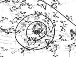
The system was first detected just to the north of the Virgin Islands as a tropical depression late on August 30. The storm moved generally west-northwest, passing to the north of the Greater Antilles and Grand Turk on the night of September 2–3. It reached minimal hurricane intensity as it passed near the Turks and Caicos Islands, and began a period of rapid strengthening shortly thereafter. It became a major hurricane early on September 4 and reached winds of 140 miles per hour (230 km/h), equivalent to those of a Category 4 hurricane, as early as the afternoon. As late as the evening of September 4, however, no winds of hurricane force were reported to the United States Weather Bureau, the highest wind being 60 mph (97 km/h) from a ship 285 mi (458.66 km) east of Miami, Florida.
The storm passed just to the east of the main islands and Nassau while continuing to strengthen. A gradual turn to the northwest and north began soon, and late on September 5 the storm peaked at Category 5 status with estimated maximum sustained winds of around 160 mph (260 km/h) at this time. Maintaining strength, the storm passed over Great Abaco on September 5 and gradually began to curve northeast away from the mainland United States. It continued northeast while weakening in intensity, delivering sea swells to the northeastern United States and winds of 56 mph (90 km/h) to Nantucket as the storm bypassed New England. The storm became extratropical on September 9, crossed south of the Avalon Peninsula, Newfoundland and Labrador, on September 11, and eventually passed near the Snæfellsnes, Iceland, and Jan Mayen Island. It dissipated on September 17.
Preparations
Initially, storm warnings in the United States were placed at 15 UTC on September 5 from Daytona Beach, Florida, to Punta Gorda, Florida. Due to the warnings, residents in the affected areas began boarding up windows and completing other preparations. As the cyclone later appeared to miss South Florida, the first warnings were cancelled and new storm warnings issued between Daytona Beach and Wilmington, North Carolina. By early September 7, warnings were extended up the Eastern Seaboard to Eastport, Maine.
Impact
16 people were reported killed, along with an additional 300 injured. This entire toll occurred in the Bahamas, notably on and around Abaco Island; damage estimates in dollars, however, were not released. Despite the large size and great intensity of the hurricane, ample warnings prevented loss of life and commerce at sea.
Bahamas
As the storm passed north of Cat Island, it caused a pressure of 29.47 inHg (998.0 mb) and a wind of 20 mph (32 km/h) from the north. Although the cyclone passed within 65 mi (105 km) of the Bahamian capital Nassau, the storm only caused winds up to 50 mph (80 km/h) and no significant damage there.
The storm was very destructive on Abaco Island, where the reported barometric pressure was below 27.50 inHg (931.3 mb). At Hope Town, strong winds shifting from northeast to southeast destroyed 83 homes and severely damaged 63. Food supplies ran low and salt contaminated the drinking supply. All public buildings along with the radio station were destroyed. The lowest pressure at Hope Town was 27.20 inHg (921.1 mb) around 15 UTC on September 5. At nearby Marsh Harbour, northeast winds shifted to southwest at 20 UTC and calm conditions occurred for 15 minutes as the eye passed. The barometer dropped as low as 27.60 inHg (934.6 mb). 12 homes were destroyed and most of the remainder severely damaged. On Green Turtle Cay, near Abaco Island, north and northwest winds coincided with the worst conditions; a large storm surge inundated the island, all buildings and the graveyard were destroyed, and at least six people died with 25 injuries reported. At nearby Coopers Town, just six homes survived the storm. Only four homes were still standing on Great Guana Cay. On Green Turtle Cay, two large brick churches with stone walls 3 ft (0.91 m) thick were destroyed by the storm and winds were estimated by one resident to have exceeded 200 mph (320 km/h); some of the stone blocks from the churches were reportedly carried 0.50 mi (0.80 km). Newspaper reports and photos helped to establish estimated prevailing winds on Green Turtle Cay that possibly exceeded 150 mph (240 km/h) during the hurricane.
After the storm passed Abaco on September 6 and 7, several vessels caught in the storm recorded winds of Force 12 (Beaufort Wind Scale) and low barometric pressures; the steamship Yankee Arrow recorded a pressure of 27.65 inHg (936.3 mb) on September 7, while the nearby steamship Deer Lodge reported a lower pressure of 27.58 inHg (934.0 mb).
United States
Although storm warnings were posted for the Florida and eastern United States coastline, the storm's recurvature prevented a landfall, leaving the main effects as heavy coastal swells and high winds. Gale-force winds affected the coastline, however. As the cyclone passed closest to New England, Nantucket recorded the highest winds at 56 mph (90 km/h) as the storm remained offshore, although it still contained hurricane-force winds. Winds peaked at 44 mph (71 km/h) at Cape Hatteras. Strong gales on the evening of September 7 caused the Cape Lookout Lightship to be blown loose from her anchorage. Off the coast at the same time, the crew of the Munson Steamer Munloyal, then believed to be 350 mi (560 km) southeast of Frying Pan Shoals, North Carolina, reported that her position was unknown and her rudder blown away. United States Coast Guard cutters from Fort Lauderdale, Florida, were dispatched to her assistance. Large trees and signs fell down in Brooklyn, New York, due to high winds. Cold temperatures followed in the wake of the hurricane.
Newfoundland, Iceland, and Jan Mayen Island
Although the storm was extratropical by the time it bypassed Newfoundland and was near Iceland and Jan Mayen Island, it was still intense: observed barometric pressures were at or below 29 inHg (982.1 mb).