
Formed October 14, 1926 Highest winds 241 km/h | Dissipated October 28, 1926 Fatalities 709 | |
 | ||
Lowest pressure 934 mbar (hPa); 27.58 inHg Date 14 October 1926 – 28 October 1926 Similar 1926 Miami hurricane, 1926 Louisiana hurricane, 1926 Nassau hurricane | ||
The 1926 Havana hurricane devastated large areas of Cuba and Bermuda in October 1926. The tenth tropical cyclone, eighth hurricane, and sixth major hurricane of the annual hurricane season, the storm formed from a low-pressure area in the southern Caribbean Sea on October 14. Moving slowly to the north, it steadily intensified, attaining hurricane intensity on October 18 near the Swan Islands. After passing the islands, the hurricane began to rapidly intensify as it accelerated to the north, attaining major hurricane intensity the following day. The storm later made two landfalls on Cuba as it reached peak intensity with winds of 150 mph (240 km/h) and a minimum central pressure of 934 mbar (hPa; 27.58 inHg). The hurricane slightly weakened as it passed over the island, and after entering the Straits of Florida, made a close pass of southern Florida and The Bahamas. Afterwards, the storm gradually weakened, passing over Bermuda on October 22, before executing a clockwise loop and dissipating on October 28, after becoming absorbed by an extratropical cyclone.
Contents
Meteorological history
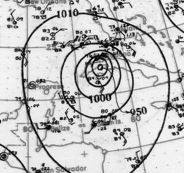
An open trough of low pressure was first observed off the eastern coast of Costa Rica in the southern Caribbean Sea on October 14. In HURDAT—the database listing all tropical cyclones in the Atlantic basin since 1851—the disturbance was listed to have attained tropical depression strength by 0600 UTC later that day. Ships in the vicinity of the storm reported low barometric pressures. Moving slowly towards the north, the depression slowly intensified, and was estimated to have reached tropical storm early the following day, based on a drop in pressures in the region. The tropical storm continued to steadily intensify, with more ship reports indicating a cyclonic circulation in the area. By 2000 UTC on October 17, the disturbance attained a minimum central pressure of 993 mbar (hPa; 29.33 inHg), with maximum sustained winds of 70 mph (110 km/h).
At 0000 UTC on October 18, the tropical storm was analyzed to have attained hurricane strength in the vicinity of the Swan Islands as it began to move towards the north-northwest. The ship S.S. Atenas observed the hurricane at 1700 UTC later that day, reporting an eye associated with the storm and a minimum pressure of 974 mbar (hPa; 28.77 inHg). After passing the Swan Islands, the system began to rapidly intensify as it accelerated towards the north. At the time, the storm was located in a region of relatively low barometric pressures, with an outermost closed isobar of 1009 mbar (hPa; 29.80 inHg). By 0600 UTC on October 19, the hurricane had already intensified to an equivalent of a Category 4 hurricane on the Saffir–Simpson hurricane scale with winds of 135 mph (215 km/h). The S.S. Mojave reported a barometric pressure of 950 mbar (hPa; 28.06 inHg) associated with hurricane force winds. The major hurricane later made landfall on the Isla de la Juventud at 0800 UTC on October 20, with a minimum pressure of 939 mbar (hPa; 27.73 inHg) based on a report from Nueva Gerona. The hurricane continued to intensify after crossing the island, reaching peak intensity at 1200 UTC later that day with maximum sustained wind speeds of 150 mph (240 km/h) and a minimum central pressure of 934 mbar (hPa; 27.58 inHg) prior to making landfall in western Cuba.
Over Cuba, the storm slightly weakened prior to entering the Straits of Florida by October 21 with winds equivalent to a Category 3 hurricane. A ship offshore the northern Cuban coast reported a minimum barometric pressure of 949 mbar (hPa; 28.03 inHg). While in the straits, the hurricane began to accelerate to the northeast, passing 20–30 mi (30–50 km) in the vicinity of the Florida Keys and Biscayne Bay. The storm later passed through The Bahamas before entering the open Atlantic Ocean while maintaining Category 3 hurricane intensity, prior to passing directly over Bermuda on October 22 with an estimated minimum pressure of 962 mbar (hPa; 28.41 inHg) based on a report from Hamilton. After passing Bermuda, the storm gradually weakened, and had degenerated to a Category 1 hurricane by 1200 UTC on October 23. The hurricane later weakened further to tropical storm strength as it recurved to the southwest. The original HURDAT listed the storm as having undergone extratropical transition late on October 23, but the Atlantic hurricane reanalysis project analyzed the storm to have lasted until October 28, prior to being absorbed by a larger extratropical cyclone.
Cuba
The hurricane made two separate landfalls on Cuba as a Category 4 hurricane on October 20. As it made landfall, numerous weather stations reported low barometric pressures. Barometers in Güira de Melena and Cojimar both recorded a barometric pressure of 939 mbar (hPa; 27.73 inHg) while located in the hurricane's eyewall. In Havana, a barometer registered a pressure of 951 mbar (hPa; 28.09 inHg) after recording a 34 mbar (hPa; 1.00 inHg) drop in pressure in 30 minutes. Offshore, strong waves damaged or sunk a large number of ships, including 40 fishing vessels. Small craft in harbors were also swept out to sea. Some ships part of the Cuban Navy were damaged, including the light cruiser Patria. The steamer Maximo Gomez broke from its harbor mooringss, causing it to collide and damage other ships before it was beached. Other foreign vessels, including one from the French West India Company were sunk.
In Havana, 20.08 in (510 mm) of rain fell on October 20, helping to inundate lower elevated areas of the city in floodwater. People in inundated areas were forced to evacuate to emergency shelters. The hurricane's effects destroyed an estimated 150 homes in the city. Some gas and oil tanks were destroyed. The Havana Automobile Company's headquarters suffered severe window damage due to the strong winds. An antenna tower was also blown down by strong winds. Power outages were widespread across other affected regions. Water and electric supply to the suburb of Marianao was cut off by the hurricane. Trees along a road from Marianao to Havana were uprooted. At the nearby Oriental Park Racetrack, numerous homes were destroyed. About 25 percent of barracks in Camp Columbia were damaged. A monument in the suburbs of Havana dedicated to victims of an explosion on the USS Maine was destroyed by high floodwaters. Police in the region were later ordered by President of Cuba Gerardo Machado to shoot people attempting to loot without warning.
Florida and The Bahamas
While the storm was just offshore Cuba on early October 20, the Weather Bureau issued warnings in Florida for the approaching system. A hurricane warning was hoisted from Punta Gorda to West Palm Beach. Additionally, northeast storm warnings were issued north of Punta Gorda to Boca Grande along the west coast and north of West Palm Beach to Titusville on the east coast. In Miami, policemen and legionnaires board up their homes and then report for duty. At the city jail, prisoners were released and were required to return on their own honor. Courthouses and schools were also closed and boarded up. A few hospitals, such as Jackson Memorial, were filled with nurses and physicians and left ambulances on standby. The Miami YMCA housed about 100 people in the gymnasium. Some people sought refuge at hotels in Coral Gables. The storm caused generally minor damage in South Florida. Strong winds were reported for four hours in Key West, with sustained winds reaching as high as 90 mph (140 km/h). However, there was little impact other than broken windows and downed street signs. In Key Largo, several dwellings were declared "total wrecks", while houses along the waterfront had several feet of standing water. The city suffered "greater than [during] the previous hurricane." Four barges were beached at Biscayne Bay. In Miami, a trolley wire and a few feeder wires fell. About 2,500 Florida Power & Light crewmen shutoff the electricity and promptly repaired the wires. Some streets in Miami Shores were covered with a small amount of debris. A canal rose 1 ft (0.30 m) in Hialeh, causing flooding on the south side.
Bermuda
In Bermuda, 40% of the structures were damaged and two homes destroyed, but otherwise damage was light in the harbor. While weather forecasters knew of the storm's approach on Bermuda, it covered the thousand miles from the Bahamas to Bermuda so rapidly it apparently struck with few warning signs aside from heavy swells. On October 21, with the eye of the storm still 700 mi (1,130 km) from Bermuda, weather forecasts from the United States called for the hurricane to strike the island on the following morning with gale force. The Arabis-class sloop HMS Valerian, based at the HMD Bermuda, was returning from providing hurricane relief in the Bahamas and was overtaken by the storm shortly before she could make harbour. Unable to enter through Bermuda's reefline, she fought the storm for more than five hours before she was sunk with the loss of 85 men. The British merchant ship Eastway was also sunk near Bermuda. Although the Valerian's commanding officer, Commander Usher, reported that there was no sign of a major storm at 08:00, when his ship was in sight of Bermuda, and when the British Army meteorologists at Prospect Camp measured the wind at 28 mph (45 km/h), by 10:00, the winds had reached 95 mph (153 km/h). When the centre of the storm passed over Bermuda at noon, the winds dropped to 8 mph (13 km/h), then increased to 114 mph (183 km/h), whereupon the Army took down its anemometer to protect it. The Royal Naval Dockyard was being hammered and never took its anemometer down. It measured 138 mph (222 km/h) at 13:00 UTC (about the same time the Valerian went down), before the wind destroyed it.