
Elevation 169 m (554 ft) Area code(s) +381(0)13 Area 43 km² Population 319 (2002) | Time zone CET (UTC+1) Car plates VŠ Local time Monday 1:22 AM | |
 | ||
Weather 12°C, Wind SE at 16 km/h, 38% Humidity | ||
u ara
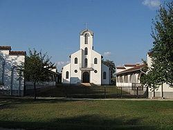
Šušara (Serbian: Šušara or Шушара, Hungarian: Fejértelep and in German: Schuschara) is a village in Serbia. It is situated in the Vršac municipality, in the South Banat District, Vojvodina province. The village has a Hungarian ethnic majority (64.09%) and its population numbering 319 people (2002 census).
Contents
Map of %C5%A0u%C5%A1ara, Serbia
u ara vetrenja a video ts teil 1
Population
In the settlement Susara 296 adult inhabitants, the average age of the population live is 40.9 years (39.3 for men and 42.5 for women). The village has 139 households, the average number of members per household is 2.71. The population in this village is very inhomogeneous and in the last three censuses were registered a decline in the population.
References
Šušara Wikipedia(Text) CC BY-SA