
Highest elevation 520 m (1,710 ft) Time zone Central European Area code +387 (051) | Lowest elevation 507 m (1,663 ft) Population 952 (1991) Municipality Kotor Varoš | |
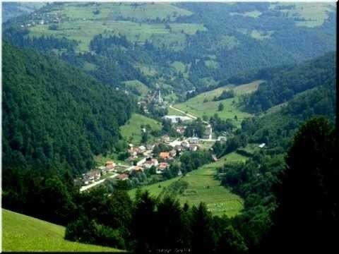 | ||
Šiprage (Serbian Cyrillic: Шипраге) is a settlement and former municipality in the Bosnia and Herzegovina, Republika Srpska entity, Kotor Varoš Municipality.
Contents
- Map of C5A0iprage Bosnia and Herzegovina
- Name
- Geography
- Nature and ecology
- History
- Bosnian War
- Population
- References
Map of %C5%A0iprage, Bosnia and Herzegovina
The administrative status of this populated place was changed – from the local community has grown a municipality in the county of Kotor Varoš – in order to ensure in the 1964th back to the level of local community.
Name
The modern name is derived from noble–bey (Omer-bey) family Šipraga. It is unclear whether their ancestors represent autochthonous population or they migrated into the area and acquired spacious property in the valley of the river Vrbanja and its tributaries. According to the oral traditions and cadastre records, their expansion started from Pougarje (slopes of Vlašić Mountain) in the valley of River Ugar.
Geography
Šiprage is on the Vrbanja river, on its south-eastern upstream line of the Banja Luka (about 60 km) and the Kotor Varoš (30 km) and the Center is part of the local community. Located in the long valley between several mountain ranges: north-east Šipraško Brdo (Šiprage's Hill) with Glavić top, 950 m, south: Jasik (769 m), to the southeast of the complex Šahinovina–Stražbenica (848 m), west: Radohova (top: Kape, 950 m) and the north-west: Borčići (799 m) with Hrastik.
The settlement, along with Vrbanja and its tributaries, is about three long and two kilometers wide. It is rich in sources of drinking water, one of which is (along the Crkvenica) used to supply the local aqueduct network. In the place, in Vrbanja confluence there are flowing: Musić potok (stream), Crkvenica and Bakin potok (Grandmother's Creek), on the right side, but Ćorkovac, Zagradinski potok (Creek) and Demićka on the left riverside.
Nature and ecology
In the Šiprage's Valley and on the surrounding slopes, along with the Vrbanja river and its tributaries, there stretches the surface of arable land, with belts of mixed deciduous and coniferous forests (spruce and abies, white and black pine) and mixed woods of beech and hornbeam. In these ecosystems and mountain meadows there are big and small game (bear, wild boar, wolf, fox, rabbit, hedgehog, badger, marten and wease, hedgehog, etc.), including Bosnian endemic quarry mammals.
Pastures, cutters and a catchment area covering the life of the natural community (biocenosis) of the associated vegetation zones. But upstream from the Obodnik village and all the way to Tomina Luka (Tom's field) in its upper flow, the Vrbanja confluence belongs to the salmonid waters. However, at first the grayling, after huchen too, and now brown trout will gradually fade away. Grayling is completely missing in the 1970s, and the survival of trout endanger numerous natural and anthropogenic factors. It is especially extreme flooding during 2000th. There are the irrational fishing and pollution with sludge and secondary by-products of exploitation of forest resources. Picking a fish stock is trying to compensate for the regular stocking of, which in turn leads to the question of local populations gene pool, because of the autochthonous specificities, even in the source area of the flows of Vrbanja river and its tributaries.
History
According to sources, the first settlement in the Vrbanja river valley dates to the Neolithic. This area was then inhabited by the Illyrian tribe of Maezaeis, and in the 4th century BC Celts. From the Roman period there are several sites in Šiprage at the mouth Crkvenica – in Vrbanja river ("at the field of Omer Bey Šipraga," 1891), discovered the remains of an early Christian basilica (3rd - 5th century). Archaeological records confirm the existence of a Roman settlement at this location, while the stećci dates to the 12th century. The original location of stećci was confluence of rivulet Crkvenica and River Vrbanja (at the very rivers' banks). They were cut out and built in the walls of the surrounding buildings (possibly due to the beliefs of their miraculous properties). One of the best preserved stećak is submerged in River Vrbanja, in the immediate proximity of its primary location.
In the Middle Ages, Šiprage belonged to the state of Bosnia, part of the province of Donji Kraji ("Lower regions"), and was later occupied by the Ottomans (1519). In 1878 the region became part of the Austro-Hungarian Monarchy, and in 1918, Yugoslavia.
During World War II, Šiprage was a Partisan stronghold, and site of the 12th Division Hospital (in Demić gorge), serving its 5th Corpus. In the area of Šiprage, at the very beginning of the war, there were several local partisan unit forces that were later included in larger formations. On 6 January 1944, the Germans broke through the partisan defence lines on the Raskršće locality between the villages of Stopan and Kerle, and the next day entered (at sunrise, January 7) the centre of Šiprage, where they stayed until 15 January 1944.
Even though this place was and left out the most important they, the more times it is bombed, with attacks of Germans and Chetniks forces, including the units of Draža Mihailović. Deep river cliffs on the slopes of the Brestovača (between Zlovarići and Dunići villages, i.e. Dunići's rocks) was hardly noticeable for the German aviation. During so called „6th Enemy Offensive" in Bosnia, former Yougoslavia, the 12th Division's Mobil Hospital were established, for theirs 5th Corpus (1943/1944). This Hospital was in two baracs and few dwelling pits. It was survived to tactics dislocation on other places (4 January 1944). That was in spite of multiple Luftwaffe's bombing on nearby Šiprage (because unprecious localizing of main target – the Hospital). As a precaution, the Hospital was relocated to the surrounding villages and further to Korićani. Then it was about 600 injured and patients moved into the village of Stopan and Lozići, then in Palivuk, Čudnić and Kruševo Brdo. After the passage of the Offensive against, for ten days (at 15 January 1944), it was returning again in Šiprage. Later it turned out that even enemy forces did not have precise information about its location. After the War, at the 1960th, the skeleton remains from a primary graves in the woods, moved to a common Partisan Memorial Cemetery in Šiprage (locality: Zagradine).
Bosnian War
During the Bosnian War (1992–95), Bosnian Serb Police and Army forces destroyed the surrounding Bosniak villages, especially those upstream along the Vrbanja to Kruševo Brdo, as well as Bosniak and Croat villages downstream to Banja Luka, and in the whole of central Bosnia. After 1996, most of the Bosniak villages were partly restored thanks to the Luxembourgish government and soldiers of the BELUGA battalion within the SFOR-EUFOR Mission. Only mosque in wide area is renewed. During the war, an Orthodox church was built in the centre of the village, on the site of the former "Forestry House" and former seat of the local administration.
Population
Note: In the period from 28th to 31st May 1973., in Central Elementary School "Rudi Čajavec" classes there were attended by 730 to 740 pupils, from third to eighth grade.