
Local time Monday 1:05 AM | Population 38,559 (30 Sep 2015) | |
 | ||
Weather 0°C, Wind NW at 11 km/h, 92% Humidity Points of interest Goishi Coast, Shakunagenoyukkogoyo Hot Spring, Chōan‑ji Temple, Tenjinyama Park, Imadeyama | ||
Ōfunato (大船渡市, Ōfunato-shi) is a city located in Iwate Prefecture, in the Tohoku region of northern Japan. As of September 2015, the city had an estimated population of 38,010 and a population density of 112 persons per km2. The total area was 323.30 square kilometres (124.83 sq mi).
Contents
- Map of Ofunato Iwate Prefecture Japan
- History
- 2011 Thoku earthquake and tsunami
- Geography
- Neighboring municipalities
- Climate
- Economy
- Education
- Railway
- Highway
- Port
- Local attractions
- International relations
- Noted people from funato
- References
Map of Ofunato, Iwate Prefecture, Japan
History
The area of present-day Ōfunato was part of ancient Mutsu Province, and has been settled since at least the Jomon period. During the Sengoku period, the area was dominated by various samurai clans before coming under the control of the Date clan during the Edo period, who ruled Sendai Domain under the Tokugawa shogunate.
The modern village of Ōfunato was created within Kessen District, Iwate on April 1, 1889. The 1896 Sanriku earthquake caused a 25-meter tsunami which killed 27,000 people in Sanriku. Ōfunato was elevated to town status on April 1, 1932. The 1933 Sanriku earthquake had a magnitude of 8.4 and caused a 28-meter tsunami which killed 1522 people.
The neighboring town of Sakari, and the villages of Akasaki, Takkon, Massaki, Ikawa and Hikoroichi merged with Ōfunato on April 1, 1952, forming the city of Ōfunato. The city became internationally famous when it was hit by a tsunami caused by the Valdivia earthquake in Chile May 22, 1960. On November 15, 2001, the town of Sanriku (from Kesen District) was merged into Ōfunato.
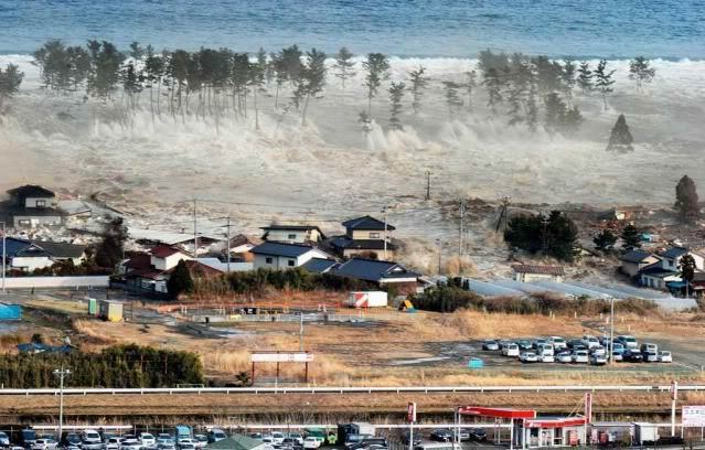
2011 Tōhoku earthquake and tsunami
Ōfunato hit the headlines yet again when it was heavily damaged in the 2011 Tōhoku earthquake and tsunami. The wave was estimated to have reached 23.6 meters in height. Funneled in by the narrow bay, the tsunami continued inland for 3 kilometres. The town's theatre was one of very few buildings left standing (and remarkably, was undamaged) and gave shelter to about 250 survivors. Provisional counts listed 3,498 houses out of 15,138 houses in the town destroyed by the tsunami and 305 lives were confirmed lost. At least six of the town's 58 designated evacuation sites were inundated by the tsunami. Ofunato was featured in the British documentary "Japan's Tsunami Caught on Camera" which was broadcast on Channel 4 in the United Kingdom.
Geography
Ōfunato is located in southeastern Iwate Prefecture, facing the Pacific Ocean. Outside its bay, the warm and cold ocean currents meet, which allow a fishing industry to flourish. The city has been trying to establish itself as a major shipping port and receives regular visits by international freight ships. Kaminari-iwa on the city's Goishi coastline has been designated one of the 100 Soundscapes of Japan by the Ministry of the Environment. Much of the city is within the borders of the Sanriku Fukkō National Park.
Neighboring municipalities
Climate
Ōfunato has a humid subtropical climate (Köppen climate classification Cfa) bordering on a humid continental climate (Köppen climate classification Dfa) with warm summers and cold winters. Precipitation is significant throughout the year, but is heaviest from April to October.
Economy
The local economy is largely based on commercial fishing.