
Local time Thursday 7:03 PM | Population 19,449 (Feb 2014) | |
 | ||
Weather 7°C, Wind SW at 18 km/h, 79% Humidity Points of interest Miracle Pine, Takata‑matsubara, Kesen Carpentry and Folkl, Fumon‑ji Temple, Hakoneyama Observation Deck | ||
Tsunami at cape hirota near rikuzentakata iwate prefecture
Rikuzentakata (陸前高田市, Rikuzentakata-shi) is a city located in Iwate Prefecture, Japan.
Contents
- Tsunami at cape hirota near rikuzentakata iwate prefecture
- Map of Rikuzentakata Iwate Prefecture Japan
- The strength of the human spirit episode 4 rikuzentakata iwate prefecture
- History
- 2011 Thoku earthquake and tsunami
- Geography
- Neighboring municipalities
- Economy
- Railway
- Highway
- Takata matsubara
- Noted people from Rikuzentakata
- References
Map of Rikuzentakata, Iwate Prefecture, Japan
In the quinquennial census of 2010, the city had a population of 23,302 (2005: 24,709) and a population density of 100 persons per km2. The 2011 Tōhoku earthquake and tsunami caused extensive damage to the city, and as of February 2014, the city had an estimated population of 19,449 and a population density of 83.7 persons per km2. The total area was 1,259.89 km2.
The strength of the human spirit episode 4 rikuzentakata iwate prefecture
History
The area of present-day Rikuzentakata was part of ancient Mutsu Province, and has been settled since at least the Jomon period. The area was inhabited by the Emishi people, and came under the control of the Yamato dynasty during the early Heian period. During the Sengoku period, the area was dominated by various samurai clans before coming under the control of the Date clan during the Edo period, who ruled Sendai Domain under the Tokugawa shogunate.
The towns of Kesen and Takada were established within Kesen District on April 1, 1889 with the establishment of the municipality system. The area was devastated by the 1896 Sanriku earthquake and the 1933 Sanriku earthquake. Kesen and Takada merged with the neighboring town of Hirota and villages of Otomo, Takekoma, Yokota and Yonezaki on January 1, 1955 to form the city of Rikuzentakata.
2011 Tōhoku earthquake and tsunami
Rikuzentakata was reported to have been "wiped off the map" by the tsunami following the Tōhoku earthquake. According to the police, every building smaller than three stories high has been completely flooded, with buildings bigger than three stories high being flooded partially, one of the buildings being the city hall, where the water also reached as high as the third floor. The Japan Self-Defense Forces initially reported that between 300 and 400 bodies were found in the town. On 14 March, an illustrated BBC report showed a picture of the town, describing it as "almost completely flattened." "It is not clear how many survived." The town's tsunami shelters were designed for a wave of three to four metres in height, but the tsunami of March 2011 created a wave 13 metres high which inundated the designated safe locations. Local officials estimate that 20% to 40% of the town's population is dead. "Rikuzen-Takata effectively no longer exists." Although the town was well prepared for earthquakes and tsunamis and had a 6.5 metre high seawall, it was not enough and more than 80% of 8,000 houses were swept away.
A BBC film dated 20 March reported that the harbour gates of the town failed to shut as the tsunami approached, and that 45 young firemen were swept away while attempting to close them manually. The same film reported that 500 bodies had been recovered in the town, but that 10,000 people were still unaccounted-for out of a population of 26,000. As of 3 April 2011, 1,000 people from the town were confirmed dead with 1,300 still missing. In late May 2011, an Australian reporter interviewed a surviving volunteer firefighter who has said 49 firefighters were killed in Rikuzentakata by the tsunami, among 284 firefighters known to have died along the affected coast, many while closing the doors of the tsunami barriers along the seashore.
Sixty-eight city officials, about one-third of the city's municipal employees, were killed. The town's mayor, Futoshi Toba, was at his post at the city hall and survived, but his wife was killed at their seaside home. The wave severely damaged the artifact and botanical collection at the city's museum and killed the staff of six people. The final death toll was 1656 killed and 223 missing and presumed dead. Portions of the city subsided by over a meter.
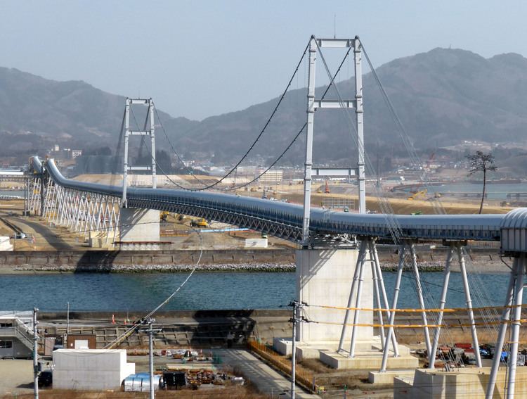
As a countermeasure against future tsunami, Rikuzentakata's city centre is being elevated upon rock fill in a megaproject. As of 2014, a massive conveyor belt system is being used to carry rock from a hill across the Kesen River from the city centre. The conveyor belt system features a long suspension span that crosses the Kesen River, and is named the "Bridge of Hope." The project is expected to elevate the city over 10 metres, and may be finished by 2018.
Geography
Rikuzentakata is located in the far southeast corner of Iwate Prefecture, bordered by the Pacific Ocean to the east. The city contained Lake Furukawanuma until the 2011 tsunami destroyed it. Parts of the coastal area of the city are within the borders of the Sanriku Fukkō National Park.
Neighboring municipalities
Economy
The local economy of Rikuzentakata was based heavily on commercial fishing and food processing. As of 2011, oyster farming produced ¥40 million in annual sales for the city.
Railway
Highway
Takata-matsubara
Takata-matsubara (高田松原) was a two-kilometre stretch of shoreline that was lined with approximately seventy thousand pines. In 1927 it was selected as one of the 100 Landscapes of Japan (Shōwa era) and in 1940 it was designated a Place of Scenic Beauty. After the 2011 tsunami a single, ten-metre, two-hundred-year-old tree remained from the forest. Due to land subsidence and coastal erosion this was only five metres from the sea and was at threat from increased salinity. The Association for the Protection of Takata-Matsubara along with the municipal and prefectural governments took measures, including the erection of barriers, to protect the surviving pine.
As of September 2011, there were signs that these measures had failed, and that the tree was dead due to salt water poisoning. In September 2012 the tree was felled for preservation and replaced in 2013 with an artificial "commemorative tree".