
Max. width 7.6 km (4.7 mi) Area 71.42 km² Length 16.4 km Mean depth 2.5 m | Max. length 16.4 km (10.2 mi) Average depth 2.5 m (8 ft 2 in) Surface elevation 30 cm Width 7.6 km | |
 | ||
Location Słowiński National Park Surface area 7,142 ha (71.42 km (27.58 sq mi)) Similar Słowiński National Park, Revekol, Muzeum Wsi Słowińskiej, Muzeum Wyrzutni Rakiet w, Hańcza | ||
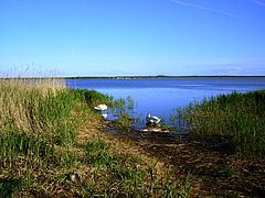
Łebsko Lake (German: Lebasee) is a coastal lake in the Pomeranian Voivodeship of Poland. It is the part of Słowiński National Park. However, it was never a part of the Baltic sea. It was formed because of the rise in the sea level and the flooding of the local meadows.
Map of %C5%81ebsko Lake, Poland
The Łeba River flows through Łebsko Lake just before it reaches the Baltic Sea at the town of Łeba. It is 16.4 km long and 7.6 km wide. Maximum depth is 6.3 m. With an area of 7,142 ha (71.42 km²), it is the largest Pomeranian lake. A 2.5 km (1.6 mi) broad spit including the 42 m (138 ft) high Łącka Góra dune separates it from the sea.
References
Łebsko Lake Wikipedia(Text) CC BY-SA