
- summer (DST) CEST (UTC+2) Area 24.06 km² | Elevation 414 m Local time Sunday 10:02 AM | |
 | ||
Weather 16°C, Wind W at 14 km/h, 51% Humidity | ||
V jezd erven kostelec dopravn nehoda vypro t n osob 08 08 2016 lhota za erven m kost
Červený Kostelec ( [ˈtʃɛrvɛniː ˈkostɛlɛts]; German: Rothkosteletz) is a town in the Hradec Králové Region of the Czech Republic. It has around 8,450 inhabitants.
Contents
- V jezd erven kostelec dopravn nehoda vypro t n osob 08 08 2016 lhota za erven m kost
- Map of 549 41 C48CervenC3BD Kostelec Czechia
- erven kostelec v dobov ch fotografi ch
- References
Map of 549 41 %C4%8Cerven%C3%BD Kostelec, Czechia
The villages of Bohdašín, Horní Kostelec, Lhota za Červeným Kostelcem, Mstětín, Olešnice and Stolín are administrative parts of Červený Kostelec.
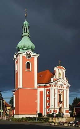
The town's church is now painted red, representing the fire, which engulfed it in the 17th century, and gave the town its name, červený meaning red. On the south is an old quarry that had been turned into an army shooting range. The large forest of Ždar envelops the southern part of the town.
erven kostelec v dobov ch fotografi ch
References
Červený Kostelec Wikipedia(Text) CC BY-SA