
Country Macedonia Time zone CET (UTC+1) Website www.caska.gov.mk Population 7,673 (2002) | Municipal seat Čaška Car Plates VE Area 819.4 km² Area code 043 | |
 | ||
Region | ||
Čaška (Macedonian: Чашка ) is a municipality in central part of Republic of Macedonia. Čaška is also the name of the village where the municipal seat is found. This municipality is part of the Vardar Statistical Region.
Contents
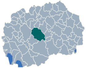
Map of Chashka, Macedonia (FYROM)
Geography
The municipality borders Studeničani Municipality and Zelenikovo Municipality to the north, Veles Municipality, Rosoman Municipality and Gradsko Municipality to the east, Makedonski Brod Municipality and Dolneni Municipality to the west, and Kavadarci Municipality and Prilep Municipality to the south.
History
By the 2003 territorial division of the Republic, the rural Bogomila Municipality and Izvor Municipality were attached to Čaška Municipality.
Tourism
There has been an increase in tourism in the municipality recently. In 2008, there were 25% more tourists than the year before. Besides domestic tourists, now there are also guests from Poland, Serbia, Slovenia, Croatia, the Czech Republic and Slovakia.
Demographics
According to the 2002 Macedonian census, Čaška Municipality has 7,673 inhabitants. Ethnic groups in the municipality: