
Time zone EET (UTC+2) Licence plate 17 Population 3,106 (2013) Area code 0286 | District Lapseki Postal code 17810 Elevation 10 m Local time Sunday 4:09 AM Province Çanakkale | |
 | ||
Weather 6°C, Wind NE at 14 km/h, 88% Humidity | ||
Çardaka is a belde (town) in Çanakkale Province, Turkey
Contents
- Map of C387ardak 17810 C387ardak Belediyesi2FLapseki2FC387anakkale Turkey
- Geography
- History
- Economy
- References
Map of %C3%87ardak, 17810 %C3%87ardak Belediyesi%2FLapseki%2F%C3%87anakkale, Turkey
Geography
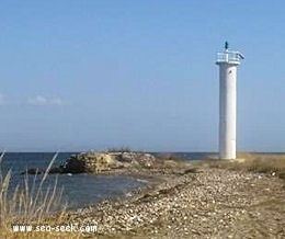
Çardak is in Lapseki district of Çanakkale Province. It is situated in the Anatolian coast of the Çanakkale (Dardanelles) Strait at 40°23′N 26°43′E. It is north east of both Lapseki and Çanakkale, the distance to Lapseki is 4 kilometres (2.5 mi)and to Çanakkle is 37 kilometres (23 mi). It is also a ferry terminal to the Rumeli (European portion of Turkey). The population of Çardak was 3144 as of 2013.
History
Çardak was founded by Turks in the 14th century as an Anatolian base for the early Ottoman operations in Rumeli. According to mayor's page the town was named by Süleyman Pasha who was the şehzade (prince) and the first Ottoman commander in Rumeli. The oldest buildings in the town belong to a complex (Turkish: Külliye) constructed by Gazi Yakup in 1479 (during the reign of Mehmet II) .
Economy
Fishing and agriculture are the two main economic sectors of the town. Tourism is also promising. The beaches of the town are in Kum ada (a small sand island) just in front of Çardak.