
Primary inflows Surface area 11.96 km (4.62 sq mi) Surface elevation 203 m Mean depth 35 m Cities Åraksbø | Max. length 32 km (20 mi) Shore length 45.22 km (28.10 mi) Area 11.96 km² Length 32 km | |
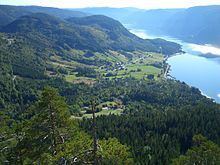 | ||
Åraksfjorden is a lake in the municipality of Bygland in Aust-Agder county, Norway. It is part of the Otra drainage basin. The villages of Frøysnes and Skåmedal are located along the western side and on the eastern side are the villages of Sandnes and Åraksbø.
Map of %C3%85raksfjorden, 4745 Bygland, Norway
The name of the lake was given because it is located near Åraksbø. The central part of the lake is also called the Sandnesfjord and the southern part is also called the Blåfjord.
References
Åraksfjorden Wikipedia(Text) CC BY-SA