
Surface area 3.24 km (1.25 sq mi) Surface elevation 583 m Length 4.8 km Shore length 11.32 km | References NVE Area 3.24 km² Width 950 m | |
 | ||
Max. length 4.8 kilometres (3.0 mi) Max. width 0.95 kilometres (0.59 mi) Reference Norwegian Water Resources and Energy Directorate | ||
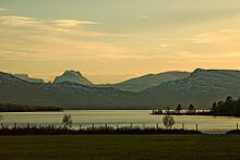
Ångardsvatnet is a lake in Storlidalen, a part of Lønset parishes in Oppdal, (Norway).
Contents
Map of %C3%85ngardsvatnet, 7342 L%C3%B8nset, Norway
Geography
This lake is the largest of the lakes in Lønset located in the Trollheimen mountains, about 35 km (the east end) west of Oppdal, surrounded by mountains Gråfjellet, no:Kråkvasstind and Lorthøa in the south and Bårdsgardskammen and Okla in the north. The lake was regulated in connection with the development of Driva power plant opened in 1973. Ångardsvatnet is associated with Dalsvatnet through Haug River (Haugelva - 1.7 km). The regulation of the lake resulted Vindøla river, which flows out of Dalsvatnet in the east end and runs into Driva right down from the village Lønset, has very little water flow in parts of the year.
Uses
The lake offers good bathing possibilities and other activities (fishing and boattrips) during the summer. Lønset landowners disposes the fishing rights and sells fishing permits for sports fishing. In winter it offers on the activities of groomed ski trails and good opportunities for the ice fishing. The annual ice fishing contest is held around Easter.