
Height 66 m Opened 6 July 1935 No. of lanes 2 | Crosses St. Lawrence River Longest span 323 m (1,060 ft) Total length 4,430 m Width 9.6 m | |
 | ||
Locale Quebec City and Île d'Orléans Similar Pierre Laporte Bridge, Quebec Bridge, Dorchester Bridge, Cap‑Rouge trestle, Laviolette Bridge | ||
The le d orl ans bridge and montmorency falls
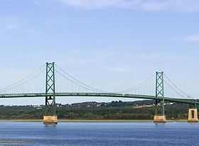
The Île d'Orléans Bridge, known locally as the Pont de l'Île, is a suspension bridge that spans the Saint Lawrence River between the Beauport borough of Quebec City and Île d'Orléans (Orléans Island) in the Canadian province of Quebec. It is part of Quebec Route 368 and connects to Autoroute 40 on the north side.
Contents
- The le d orl ans bridge and montmorency falls
- Map of Orleans Island Bridge Beauport QC Canada
- References
Map of Orleans Island Bridge, Beauport, QC, Canada
The island was originally accessible only by ferry or by ice bridge during the winter. An electoral promise made by Premier Louis-Alexandre Taschereau to Montmorency County for a job-creation project during the Great Depression led to the construction of this bridge in 1934. It was completed in 1935 and initially named Taschereau Bridge.
It is the farthest downstream of the Saint Lawrence River's fixed crossings, but it does not cross the entire river.