
Basin countries France Max. width 8 km (5.0 mi) Surface elevation 0 cm Mean depth 4 m | Max. length 21 km (13 mi) Area 70.12 km² Length 21 km | |
 | ||
Surface area 7,012 ha (17,330 acres) Similar Canal du Midi, Mont Saint‑Clair, Cap d'Agde, Lagoon, Lac du Salagou | ||
Pilou34 pr sente p che et balade sur l etang de thau
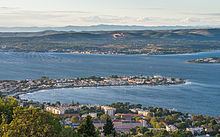
Étang de Thau ([etɑ̃ də to]; Occitan: Estanh de Taur) or Bassin de Thau is the largest of a string of lagoons (étangs) that stretch along the French coast from the Rhône River to the foothills of the Pyrenees and the border to Spain in the Languedoc-Roussillon. Although it has a high salinity, it is considered the second largest lake in France.
Contents
- Pilou34 pr sente p che et balade sur l etang de thau
- Map of C389tang de Thau France
- DescriptionEdit
- AdministrationEdit
- WildlifeEdit
- References
Map of %C3%89tang de Thau, France
DescriptionEdit
It is about 21 km long and 8 km wide, with an area of 7,012 hectares. The mean depth of the lagoon is 4.5m, but in the central navigation channel it can be 10 metres deep. Near Bouzigues there is a 100-metre diameter depression of 30 metres. This 'Fosse de la Vise' is the source of a hot spring that feeds the spa in Balaruc.
Its size and depth, which distinguish it from other lagoons of the region, is explained by the geomorphology of the region: it is the anticline formed from folding which produced the corresponding syncline of the Gardiole in the north east.
Until relatively recently the lagoons from Marseillan to the Rhône were a continuous stretch of inland waterway. Early settlers described this as 'une petite mer intérieure et tranquille'. It provided access to, in particular, Marseillan - a fishing village that became a trade centre.
Linked, now, by the Canal du Rhône à Sète to the river Rhône and by the Canal du Midi to Bordeaux via Toulouse, the lagoon also has access to the Mediterranean at Sète. There is also a small canal 'le canal des Allemands' or the 'pisse-saume' that links the western end to the sea at Marseillan Plage. This canal is only suitable for small craft since both road and railway bridges restrict height.
To the east, between Balaruc and Sète, the borders of the lagoon are largely industrial. The south bank is formed by the coastal strip from Sète to Cap d'Agde. The northern side has villages dedicated to fishing and the production of shellfish. There are harbours in the towns of Marseillan, Mèze and Bouzigues, with smaller ports dedicated to shellfish on the northern shore.
There is significant variation in the rainfall in the catchment basin for the lagoon, both seasonally and between years. The annual precipitation can range from 200 to 1,000 mm per year. As a result, the water temperature and salinity have extensive ranges. Water temperature ranges from 3 °C to 29 °C, with salinities of 27 psu to 40 psu. The salinity changes during the year with lows from February to June and peaks in July to January.
AdministrationEdit
Located between the towns of Sète and Marseillan in the Hérault département, the Étang de Thau is shared administratively by the communes of (running clockwise): Balaruc-le-Vieux, Balaruc-les-Bains, Frontignan, Sète, Marseillan, Mèze, Loupian and Bouzigues.
WildlifeEdit
The Bassin de Thau provides a habitat for a variety of wild animals, notably birds such as herons and pink flamingos and a rich marine fauna, including bivalves (oysters and mussels), jellyfish, fish, and algae. Periodically in the spring and summer, the Thau Lagoon has algae blooms of Alexandrium catenella which sometimes reach such high levels that it results in contamination of the lagoon's bivalves with algae toxins.