
Surface area 155.3 km (60.0 sq mi) Surface elevation 40 cm | Basin countries France Area 155.3 km² Width 16 km | |
 | ||
Primary inflows Primary outflows canal de Caronte, canal du Rove Catchment area 1,700 km (660 sq mi) (natural) Similar Touloubre, Durance, Alpilles, Rove Tunnel, Montagne Sainte‑Victoire | ||
Sur le rocher vue de l tang de berre vitrolles france 2014
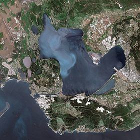
The Étang de Berre (in Provençal Occitan: estanh de Bèrra / mar de Bèrra according to classical orthography, estang de Berro / mar de Berro according to Mistralian orthography) is a lagoon on the Mediterranean coast of France, about 25 km north-west of Marseille.
Contents
- Sur le rocher vue de l tang de berre vitrolles france 2014
- Map of C389tang de Berre France
- GeographyEdit
- AdministrationEdit
- HistoryEdit
- References
Map of %C3%89tang de Berre, France
GeographyEdit
Created by the rise in water levels at the end of the last ice age, this small inland sea is composed of three parts: the principal body of water, the Étang de Vaïn to the east and the Étang de Bolmon to the south-east.
The Étang de Berre is fed with fresh water by the rivers Arc, Touloubre and La Cadière-d'Azur and – since 1966 – by the Canal de la Durance. Two canals link it to the sea: the Canal de Caronte leading towards Port-de-Bouc and the Canal du Rove which leads towards L'Estaque. However the underground portion of the latter is blocked by a rock fall.
The Marseille Provence Airport is located in the southeast portion of the Étang Barre, with its main runway extending into the water on reclaimed land.
AdministrationEdit
Ten communes border the Étang de Berre: Istres, Miramas, Saint-Chamas, Berre-l'Étang, Rognac, Vitrolles, Marignane, Châteauneuf-les-Martigues, Martigues and Saint-Mitre-les-Remparts.
HistoryEdit
The ancient name of the Étang de Berre was Stagnum Mastromela, according to Pliny the Elder (Book III [34]).